
Topografische Karte Villance
Interaktive Karte
Klicken Sie auf die Karte, um die Höhe anzuzeigen.
Über diese Karte
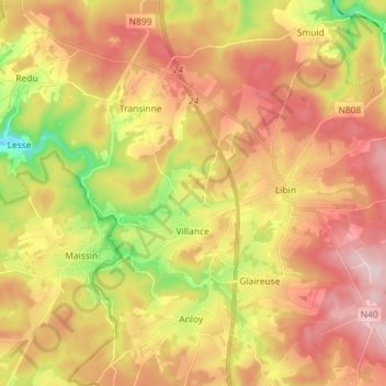
Name: Topografische Karte Villance, Höhe, Relief.
Ort: Villance, Libin, Neufchâteau, Luxemburg, Wallonië, 6890, België (49.93516 5.17957 50.02501 5.32343)
Durchschnittliche Höhe: 405 m
Minimale Höhe: 263 m
Maximale Höhe: 518 m
Andere topografische Karten
Klicken Sie auf eine Karte, um ihre Topografie, ihre Höhe und ihr Relief anzuzeigen.
Resteigne
België > Luxemburg > Neufchâteau > Tellin
Resteigne, Tellin, Neufchâteau, Luxemburg, Wallonië, 6927, België
Durchschnittliche Höhe: 301 m
Moircy
België > Luxemburg > Neufchâteau
Moircy, Libramont-Chevigny, Neufchâteau, Luxemburg, Wallonië, België
Durchschnittliche Höhe: 474 m
Les Fossés
België > Luxemburg > Neufchâteau
Les Fossés, Léglise, Neufchâteau, Luxemburg, Wallonië, België
Durchschnittliche Höhe: 423 m
Assenois
België > Luxemburg > Neufchâteau
Assenois, Léglise, Neufchâteau, Luxemburg, Wallonië, België
Durchschnittliche Höhe: 417 m
Tellin
België > Luxemburg > Neufchâteau
Tellin, Neufchâteau, Luxemburg, Wallonië, 6927, België
Durchschnittliche Höhe: 310 m
Libin
België > Luxemburg > Neufchâteau
Libin, Neufchâteau, Luxemburg, Wallonië, 6890, België
Durchschnittliche Höhe: 417 m
Carlsbourg
België > Luxemburg > Neufchâteau > Paliseul
Carlsbourg, Paliseul, Neufchâteau, Luxemburg, Wallonië, België
Durchschnittliche Höhe: 412 m
Bertrix
België > Luxemburg > Neufchâteau
Bertrix, Neufchâteau, Luxemburg, Wallonië, 6880, België
Durchschnittliche Höhe: 403 m
Grupont
België > Luxemburg > Neufchâteau > Tellin
Grupont, Tellin, Neufchâteau, Luxemburg, Wallonië, België
Durchschnittliche Höhe: 324 m
Transinne
België > Luxemburg > Neufchâteau
Transinne, Libin, Neufchâteau, Luxemburg, Wallonië, België
Durchschnittliche Höhe: 397 m
Redu
België > Luxemburg > Neufchâteau
Redu, Libin, Neufchâteau, Luxemburg, Wallonië, België
Durchschnittliche Höhe: 362 m
Neuvillers
België > Luxemburg > Neufchâteau
Neuvillers, Recogne, Libramont-Chevigny, Neufchâteau, Luxemburg, Wallonië, België
Durchschnittliche Höhe: 470 m
Haut-Fays
België > Luxemburg > Neufchâteau
Haut-Fays, Daverdisse, Neufchâteau, Luxemburg, Wallonië, 6929, België
Durchschnittliche Höhe: 387 m
Jehonville
België > Luxemburg > Neufchâteau > Bertrix
Jehonville, Bertrix, Neufchâteau, Luxemburg, Wallonië, België
Durchschnittliche Höhe: 424 m
Ochamps
België > Luxemburg > Neufchâteau > Ochamps
Ochamps, Libin, Neufchâteau, Luxemburg, Wallonië, België
Durchschnittliche Höhe: 445 m
Mirwart
België > Luxemburg > Neufchâteau > Saint-Hubert
Mirwart, Saint-Hubert, Neufchâteau, Luxemburg, Wallonië, België
Durchschnittliche Höhe: 358 m
Léglise
België > Luxemburg > Neufchâteau
Léglise, Neufchâteau, Luxemburg, Wallonië, 6860, België
Durchschnittliche Höhe: 441 m
Cugnon
België > Luxemburg > Neufchâteau > Cugnon
Cugnon, Bertrix, Neufchâteau, Luxemburg, Wallonië, België
Durchschnittliche Höhe: 330 m
Poupehan
België > Luxemburg > Neufchâteau > Bouillon
Poupehan, Bouillon, Neufchâteau, Luxemburg, Wallonië, België
Durchschnittliche Höhe: 270 m
Wellin
België > Luxemburg > Neufchâteau
Wellin, Neufchâteau, Luxemburg, Wallonië, België
Durchschnittliche Höhe: 283 m
Dohan
België > Luxemburg > Neufchâteau > Bouillon
Dohan, Bouillon, Neufchâteau, Luxemburg, Wallonië, België
Durchschnittliche Höhe: 281 m
Corbion
België > Luxemburg > Neufchâteau > Bouillon
Corbion, Bouillon, Neufchâteau, Luxemburg, Wallonië, 6838, België
Durchschnittliche Höhe: 338 m
Rochehaut
België > Luxemburg > Neufchâteau > Rochehaut
Rochehaut, Bouillon, Neufchâteau, Luxemburg, Wallonië, België
Durchschnittliche Höhe: 296 m
Saint-Hubert
België > Luxemburg > Neufchâteau
Saint-Hubert, Neufchâteau, Luxemburg, Wallonië, 6870, België
Durchschnittliche Höhe: 451 m
Paliseul
België > Luxemburg > Neufchâteau
Paliseul, Neufchâteau, Luxemburg, Wallonië, België
Durchschnittliche Höhe: 393 m
Laneuville
België > Luxemburg > Neufchâteau > Saint-Marie-Chevigny
Laneuville, Saint-Marie-Chevigny, Libramont-Chevigny, Neufchâteau, Luxemburg, Wallonië, België
Durchschnittliche Höhe: 496 m
Poix-Saint-Hubert
België > Luxemburg > Neufchâteau > Arville
Poix-Saint-Hubert, Arville, Saint-Hubert, Neufchâteau, Luxemburg, Wallonië, België
Durchschnittliche Höhe: 380 m