
Topografische Karte Kerorven
Interaktive Karte
Klicken Sie auf die Karte, um die Höhe anzuzeigen.
Über diese Karte
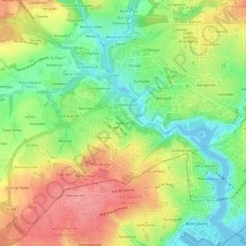
Name: Topografische Karte Kerorven, Höhe, Relief.
Durchschnittliche Höhe: 48 m
Minimale Höhe: -3 m
Maximale Höhe: 103 m
Andere topografische Karten
Klicken Sie auf eine Karte, um ihre Topografie, ihre Höhe und ihr Relief anzuzeigen.
Coat ar Piquet
France > Bretagne > Finistère > Brest
Coat ar Piquet, Brest, Finistère, Bretagne, France métropolitaine, 29200, France
Durchschnittliche Höhe: 77 m
Château de Brest
France > Bretagne > Finistère > Brest
Château de Brest, Boulevard des Français Libres, Pontaniou, Recouvrance, Brest, Finistère, Bretagne, France métropolitaine, 29200, France
Durchschnittliche Höhe: 21 m
Mesmerrien
France > Bretagne > Finistère > Brest
Mesmerrien, Brest, Finistère, Bretagne, France métropolitaine, 29200, France
Durchschnittliche Höhe: 77 m
Grand Kerjean
France > Bretagne > Finistère > Brest
Grand Kerjean, Brest, Finistère, Bretagne, France métropolitaine, 29200, France
Durchschnittliche Höhe: 32 m
Kerbernard
France > Bretagne > Finistère > Brest
Kerbernard, Brest, Finistère, Bretagne, France métropolitaine, 29200, France
Durchschnittliche Höhe: 71 m
Sainte-Anne-du-Portzic
France > Bretagne > Finistère > Brest
Sainte-Anne-du-Portzic, Brest, Finistère, Bretagne, France métropolitaine, 29200, France
Durchschnittliche Höhe: 43 m
Point du Jour
France > Bretagne > Finistère > Brest
Point du Jour, Brest, Finistère, Bretagne, France métropolitaine, 29200, France
Durchschnittliche Höhe: 50 m
Le Petit Spernot
France > Bretagne > Finistère > Brest > Le Petit Spernot
Le Petit Spernot, Brest, Finistère, Bretagne, France métropolitaine, 29200, France
Durchschnittliche Höhe: 55 m
Traon-Stivel
France > Bretagne > Finistère > Brest > Traon-Stivel
Traon-Stivel, Brest, Finistère, Bretagne, France métropolitaine, 29200, France
Durchschnittliche Höhe: 63 m
Kerarbleiz
France > Bretagne > Finistère > Brest
Kerarbleiz, Brest, Finistère, Bretagne, France métropolitaine, 29200, France
Durchschnittliche Höhe: 57 m