
Topografische Karte Grahn
Interaktive Karte
Klicken Sie auf die Karte, um die Höhe anzuzeigen.
Über diese Karte
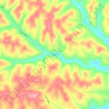
Name: Topografische Karte Grahn, Höhe, Relief.
Ort: Grahn, Carter County, Kentucky, 41142, United States (38.26369 -83.09517 38.30369 -83.05517)
Durchschnittliche Höhe: 266 m
Minimale Höhe: 195 m
Maximale Höhe: 319 m
Andere topografische Karten
Klicken Sie auf eine Karte, um ihre Topografie, ihre Höhe und ihr Relief anzuzeigen.
Wolf
United States > Kentucky > Carter County
Wolf, Carter County, Kentucky, United States
Durchschnittliche Höhe: 271 m
Grayson
United States > Kentucky > Carter County
Grayson, Carter County, Kentucky, United States
Durchschnittliche Höhe: 208 m
Denton
United States > Kentucky > Carter County
Denton, Carter County, Kentucky, 41132, United States
Durchschnittliche Höhe: 232 m
Hitchins
United States > Kentucky > Carter County
Hitchins, Carter County, Kentucky, 41146, United States
Durchschnittliche Höhe: 215 m
Olive Hill
United States > Kentucky > Carter County
Olive Hill, Carter County, Kentucky, 41164, United States
Durchschnittliche Höhe: 274 m