
Topografische Karte Heavens Peak
Interaktive Karte
Klicken Sie auf die Karte, um die Höhe anzuzeigen.
Über diese Karte
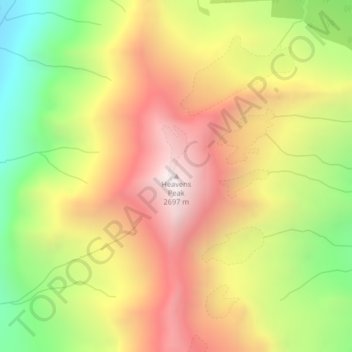
Name: Topografische Karte Heavens Peak, Höhe, Relief.
Ort: Heavens Peak, Flathead County, Montana, United States (48.70881 -113.85628 48.70891 -113.85618)
Durchschnittliche Höhe: 2.055 m
Minimale Höhe: 1.317 m
Maximale Höhe: 2.729 m
Andere topografische Karten
Klicken Sie auf eine Karte, um ihre Topografie, ihre Höhe und ihr Relief anzuzeigen.
Glacier National Park
United States > Montana > Flathead County
Glacier National Park, Flathead County, Montana, United States
Durchschnittliche Höhe: 1.594 m
Whitefish
United States > Montana > Flathead County
Whitefish, Flathead County, Montana, United States
Durchschnittliche Höhe: 1.073 m
Logan Pass
United States > Montana > Flathead County
Logan Pass, Flathead County, Montana, United States
Durchschnittliche Höhe: 2.040 m
Marion
United States > Montana > Flathead County
Marion, Flathead County, Montana, United States
Durchschnittliche Höhe: 1.236 m
Kalispell
United States > Montana > Flathead County
Kalispell, Flathead County, Montana, United States
Durchschnittliche Höhe: 934 m
Niarada
United States > Montana > Flathead County
Niarada, Flathead County, Montana, United States
Durchschnittliche Höhe: 1.053 m
Evergreen
United States > Montana > Flathead County
Evergreen, Flathead County, Montana, United States
Durchschnittliche Höhe: 895 m
Columbia Falls
United States > Montana > Flathead County
Columbia Falls, Flathead County, Montana, 59912, United States
Durchschnittliche Höhe: 934 m
Condor Peak
United States > Montana > Flathead County
Condor Peak, Flathead County, Montana, United States
Durchschnittliche Höhe: 1.848 m
Apgar
United States > Montana > Flathead County
Apgar, Flathead County, Montana, 59936, United States
Durchschnittliche Höhe: 1.080 m
Somers
United States > Montana > Flathead County
Somers, Flathead County, Montana, United States
Durchschnittliche Höhe: 915 m
Lakeside
United States > Montana > Flathead County
Lakeside, Flathead County, Montana, 59922, United States
Durchschnittliche Höhe: 1.034 m
Bigfork
United States > Montana > Flathead County
Bigfork, Flathead County, Montana, United States
Durchschnittliche Höhe: 922 m
Bowman Lake
United States > Montana > Flathead County
Bowman Lake, Flathead County, Montana, United States
Durchschnittliche Höhe: 1.639 m
Polebridge
United States > Montana > Flathead County
Polebridge, Flathead County, Montana, 59928, United States
Durchschnittliche Höhe: 1.118 m
Kalispell
United States > Montana > Flathead County > Kalispell
Kalispell, Flathead County, Montana, 59901-4451, United States
Durchschnittliche Höhe: 1.055 m
Canyon Point
United States > Montana > Flathead County
Canyon Point, Flathead County, Montana, United States
Durchschnittliche Höhe: 1.750 m
Graves Creek
United States > Montana > Flathead County
Graves Creek, Flathead County, Montana, United States
Durchschnittliche Höhe: 1.694 m
Lake McDonald
United States > Montana > Flathead County
Lake McDonald, Flathead County, Montana, United States
Durchschnittliche Höhe: 1.209 m
Kila
United States > Montana > Flathead County
Kila, Flathead County, Montana, 59920, United States
Durchschnittliche Höhe: 1.013 m
Lake Ellen Wilson
United States > Montana > Flathead County
Lake Ellen Wilson, Flathead County, Montana, United States
Durchschnittliche Höhe: 2.100 m
West Glacier
United States > Montana > Flathead County
West Glacier, Flathead County, Montana, 59936, United States
Durchschnittliche Höhe: 1.201 m
Coal Creek
United States > Montana > Flathead County
Coal Creek, Flathead County, Montana, United States
Durchschnittliche Höhe: 1.287 m
Cone Peak
United States > Montana > Flathead County
Cone Peak, Flathead County, Montana, United States
Durchschnittliche Höhe: 1.819 m