
Topografische Karte Makrinitsa
Interaktive Karte
Klicken Sie auf die Karte, um die Höhe anzuzeigen.
Über diese Karte
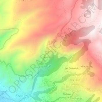
Name: Topografische Karte Makrinitsa, Höhe, Relief.
Durchschnittliche Höhe: 663 m
Minimale Höhe: 63 m
Maximale Höhe: 1.136 m
Andere topografische Karten
Klicken Sie auf eine Karte, um ihre Topografie, ihre Höhe und ihr Relief anzuzeigen.
Agios Ioannis
Greece > Thessaly and Central Greece > Regional Unit of Magnesia > Volos Municipality > Portaria
Agios Ioannis, Portaria, Volos Municipality, Regional Unit of Magnesia, Thessaly, Thessaly and Central Greece, 370 11, Greece
Durchschnittliche Höhe: 815 m
Ano Volos
Greece > Thessaly and Central Greece > Regional Unit of Magnesia > Volos Municipality
Ano Volos, Volos Municipality, Regional Unit of Magnesia, Thessaly, Thessaly and Central Greece, 385 00, Greece
Durchschnittliche Höhe: 289 m
Volos Municipality
Greece > Thessaly and Central Greece > Regional Unit of Magnesia > Volos Municipality
Volos Municipality, Regional Unit of Magnesia, Thessaly, Thessaly and Central Greece, Greece
Durchschnittliche Höhe: 228 m