
Spenden
Rüsten Sie sich für Ihr nächstes Abenteuer:
Als Amazon-Partner erhält diese Website eine Provision für qualifizierte Käufe, ohne zusätzliche Kosten für Sie.
Topografische Karte James Island
Klicken Sie auf die Karte, um die Höhe anzuzeigen.
Spenden
Rüsten Sie sich für Ihr nächstes Abenteuer:
Als Amazon-Partner erhält diese Website eine Provision für qualifizierte Käufe, ohne zusätzliche Kosten für Sie.
James Island
James Island, one of British Columbia's Gulf Islands, lies in Haro Strait between Sidney Island and the coast of Vancouver Island near Sidney, British Columbia. James Island is approximately 2.4 km (1.5 mi) from the coast of Vancouver Island, and 145 km (90 mi) from Seattle, Washington. James Island has an elevation of 145 metres (476 feet) above sea level at its highest point, and has a total land-mass of 315 hectares (780 acres). There are sea-cliffs on the Southern, Western, and Eastern shores of this island. The Southern sea-cliffs are the highest.
Spenden
Rüsten Sie sich für Ihr nächstes Abenteuer:
Als Amazon-Partner erhält diese Website eine Provision für qualifizierte Käufe, ohne zusätzliche Kosten für Sie.
Über diese Karte
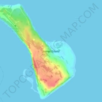
Name: Topografische Karte James Island, Höhe, Relief.
Durchschnittliche Höhe: 8 m
Minimale Höhe: -1 m
Maximale Höhe: 63 m
Spenden
Rüsten Sie sich für Ihr nächstes Abenteuer:
Als Amazon-Partner erhält diese Website eine Provision für qualifizierte Käufe, ohne zusätzliche Kosten für Sie.
Andere topografische Karten
Klicken Sie auf eine Karte, um ihre Topografie, ihre Höhe und ihr Relief anzuzeigen.
Mayne
Canada > British Columbia > Capital Regional District > Southern Gulf Islands Electoral Area
Durchschnittliche Höhe: 52 m
Mount Parke
Canada > British Columbia > Capital Regional District > Southern Gulf Islands Electoral Area
Durchschnittliche Höhe: 74 m
Mayne
Canada > British Columbia > Capital Regional District > Southern Gulf Islands Electoral Area
Durchschnittliche Höhe: 52 m
Mayne
Canada > British Columbia > Capital Regional District > Southern Gulf Islands Electoral Area
Durchschnittliche Höhe: 52 m
Spenden
Rüsten Sie sich für Ihr nächstes Abenteuer:
Als Amazon-Partner erhält diese Website eine Provision für qualifizierte Käufe, ohne zusätzliche Kosten für Sie.