
Topografische Karte Of
Interaktive Karte
Klicken Sie auf die Karte, um die Höhe anzuzeigen.
Über diese Karte
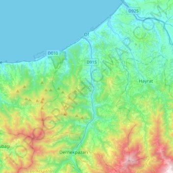
Name: Topografische Karte Of, Höhe, Relief.
Ort: Of, Trabzon, Black Sea Region, 61830, Turkey (40.77508 40.18978 40.98833 40.47715)
Durchschnittliche Höhe: 414 m
Minimale Höhe: 0 m
Maximale Höhe: 1.897 m
There are several stories about the origins of Of's name. Of was called Ofis in 1910 by Pontic Greek speaking inhabitants. According to another view it means "village" or "settlement" in the Laz language (Laz: ოფუტე/oput'e), as the old name of the town is mentioned as "Opiunte" on the Tabula Peutingeriana. By another version of events, the city got its name from a nearby river described by Arrian as Ophis, a Greek word for "snake". The Ophius stream - which snakes (zigzags) its way from around 3300 meters altitude in the Pontic Mountains towards the coastal town of Of - was renamed as "Solaklı" during the 1950s Turkification process which is a common policy in all of Turkey.
Andere topografische Karten
Klicken Sie auf eine Karte, um ihre Topografie, ihre Höhe und ihr Relief anzuzeigen.
Ortahisar Mahallesi
Ortahisar Mahallesi, Ortahisar, Trabzon, Black Sea Region, Turkey
Durchschnittliche Höhe: 72 m
Atapark
Turkey > Trabzon > Ortahisar > Gülbaharhatun Mahallesi
Atapark, Gülbaharhatun, Gülbaharhatun Mahallesi, Ortahisar, Trabzon, Black Sea Region, Turkey
Durchschnittliche Höhe: 63 m