
Topografische Karte Marston
Interaktive Karte
Klicken Sie auf die Karte, um die Höhe anzuzeigen.
Über diese Karte
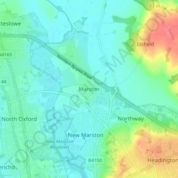
Name: Topografische Karte Marston, Höhe, Relief.
Ort: Marston, Oxford, Oxfordshire, England, OX3 0PX, United Kingdom (51.75615 -1.25791 51.79615 -1.21791)
Durchschnittliche Höhe: 71 m
Minimale Höhe: 54 m
Maximale Höhe: 122 m
Andere topografische Karten
Klicken Sie auf eine Karte, um ihre Topografie, ihre Höhe und ihr Relief anzuzeigen.
Botley Stream
United Kingdom > England > Oxfordshire > Oxford
Botley Stream, New Botley, West Oxford, Oxford, Oxfordshire, England, OX2 0ED, United Kingdom
Durchschnittliche Höhe: 67 m
Binsey
United Kingdom > England > Oxfordshire > Oxford
Binsey, Oxford, Oxfordshire, England, OX2 0NG, United Kingdom
Durchschnittliche Höhe: 64 m
Oxford
United Kingdom > England > Oxfordshire > Oxford
Oxford, Oxfordshire, South East England, England, OX1 3HY, United Kingdom
Durchschnittliche Höhe: 81 m
The Triangle
United Kingdom > England > Oxfordshire > Oxford
The Triangle, Iffley, Oxford, Oxfordshire, South East England, England, United Kingdom
Durchschnittliche Höhe: 63 m
Littlemore
United Kingdom > England > Oxfordshire > Oxford
Littlemore, Oxford, Oxfordshire, England, United Kingdom
Durchschnittliche Höhe: 67 m