
Spenden
Rüsten Sie sich für Ihr nächstes Abenteuer:
Als Amazon-Partner erhält diese Website eine Provision für qualifizierte Käufe, ohne zusätzliche Kosten für Sie.
Topografische Karte Archer Lake
Klicken Sie auf die Karte, um die Höhe anzuzeigen.
Spenden
Rüsten Sie sich für Ihr nächstes Abenteuer:
Als Amazon-Partner erhält diese Website eine Provision für qualifizierte Käufe, ohne zusätzliche Kosten für Sie.
Über diese Karte
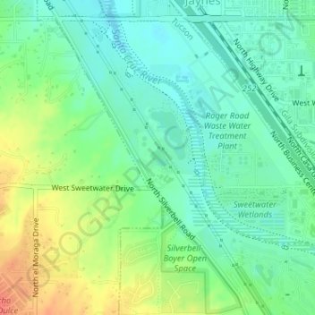
Name: Topografische Karte Archer Lake, Höhe, Relief.
Ort: Archer Lake, Tucson, Pima County, Arizona, United States (32.28157 -111.03433 32.28302 -111.03246)
Durchschnittliche Höhe: 695 m
Minimale Höhe: 677 m
Maximale Höhe: 725 m
Spenden
Rüsten Sie sich für Ihr nächstes Abenteuer:
Als Amazon-Partner erhält diese Website eine Provision für qualifizierte Käufe, ohne zusätzliche Kosten für Sie.
Andere topografische Karten
Klicken Sie auf eine Karte, um ihre Topografie, ihre Höhe und ihr Relief anzuzeigen.
Tucson
United States > Arizona > Pima County > Tucson
The city's elevation is 2,643 ft (806 m) above sea level (as measured at the Tucson International Airport). Tucson is on an alluvial plain in the Sonoran Desert, surrounded by five minor ranges of mountains: the Santa Catalina Mountains and the Tortolita Mountains to the north, the Santa Rita Mountains to the…
Durchschnittliche Höhe: 836 m
Drexel Heights
United States > Arizona > Pima County > Tucson
The area has numerous Saguaro cacti, and is positioned only a couple of miles south of the Saguaro National Park. The northern boundary of Drexel Heights is the Tucson Mountain Park. It is cut off from the rest of Tucson due to the topography of the Tucson Mountains, which are only crossed via a small number…
Durchschnittliche Höhe: 786 m
Spenden
Rüsten Sie sich für Ihr nächstes Abenteuer:
Als Amazon-Partner erhält diese Website eine Provision für qualifizierte Käufe, ohne zusätzliche Kosten für Sie.