
Topografische Karte Adjala–Tosorontio
Interaktive Karte
Klicken Sie auf die Karte, um die Höhe anzuzeigen.
Über diese Karte
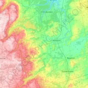
Name: Topografische Karte Adjala–Tosorontio, Höhe, Relief.
Durchschnittliche Höhe: 314 m
Minimale Höhe: 186 m
Maximale Höhe: 526 m
Andere topografische Karten
Klicken Sie auf eine Karte, um ihre Topografie, ihre Höhe und ihr Relief anzuzeigen.
Oak Ridges
Canada > Ontario > Simcoe County > Adjala–Tosorontio
Oak Ridges, Adjala–Tosorontio, New Tecumseth, Simcoe County, Central Ontario, Ontario, L0M 1J0, Canada
Durchschnittliche Höhe: 274 m