
Topografische Karte Obakamiga River;Redfin Lake
Interaktive Karte
Klicken Sie auf die Karte, um die Höhe anzuzeigen.
Über diese Karte
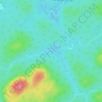
Name: Topografische Karte Obakamiga River;Redfin Lake, Höhe, Relief.
Durchschnittliche Höhe: 343 m
Minimale Höhe: 319 m
Maximale Höhe: 425 m
Andere topografische Karten
Klicken Sie auf eine Karte, um ihre Topografie, ihre Höhe und ihr Relief anzuzeigen.
Esnagi Lake
Canada > Ontario > Algoma District > Unorganized North Algoma
Esnagi Lake, Unorganized North Algoma, Algoma District, Northeastern Ontario, Ontario, Canada
Durchschnittliche Höhe: 391 m
Goulais Bay
Canada > Ontario > Algoma District > Unorganized North Algoma
Goulais Bay, Unorganized North Algoma, Algoma District, Northeastern Ontario, Ontario, Canada
Durchschnittliche Höhe: 189 m
Dog Lake
Canada > Ontario > Algoma District > Unorganized North Algoma
Dog Lake, Unorganized North Algoma, Algoma District, Northeastern Ontario, Ontario, Canada
Durchschnittliche Höhe: 364 m
Girdwood
Canada > Ontario > Algoma District > Unorganized North Algoma
Girdwood, Unorganized North Algoma, Algoma District, Northeastern Ontario, Ontario, Canada
Durchschnittliche Höhe: 442 m