
Topografische Karte Blackwater River
Interaktive Karte
Klicken Sie auf die Karte, um die Höhe anzuzeigen.
Über diese Karte
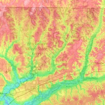
Name: Topografische Karte Blackwater River, Höhe, Relief.
Ort: Blackwater River, Santa Rosa County, Florida, 32572, USA (30.58287 -87.03537 31.02867 -86.70921)
Durchschnittliche Höhe: 47 m
Minimale Höhe: -3 m
Maximale Höhe: 96 m
Andere topografische Karten
Klicken Sie auf eine Karte, um ihre Topografie, ihre Höhe und ihr Relief anzuzeigen.
St. Augustine
USA > Florida > St. Augustine
St. Augustine, St. Johns County, Florida, 32084, USA
Durchschnittliche Höhe: 5 m
Dawson Island
USA > Florida > Jacksonville
Dawson Island, Jacksonville, Duval County, Florida, USA
Durchschnittliche Höhe: 2 m
Dry Tortugas National Park
Dry Tortugas National Park, Monroe County, Florida, USA
Durchschnittliche Höhe: 0 m
Deerfield Beach
USA > Florida > Deerfield Beach
Deerfield Beach, Broward County, Florida, USA
Durchschnittliche Höhe: 5 m