
Topografische Karte Nubra
Interaktive Karte
Klicken Sie auf die Karte, um die Höhe anzuzeigen.
Über diese Karte
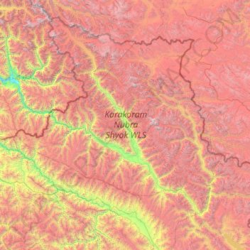
Name: Topografische Karte Nubra, Höhe, Relief.
Ort: Nubra, Leh District, Ladakh, 194401, India (33.97611 76.66317 35.67455 79.04537)
Durchschnittliche Höhe: 4.978 m
Minimale Höhe: 2.471 m
Maximale Höhe: 7.793 m
The Shyok River meets the Nubra River (or Siachan River) to form a large valley that separates the Ladakh and Karakoram Ranges. The Shyok river is a tributary of the Indus river. The average altitude of the valley is more than 10,000 feet (3,000 m) above the sea level. The most common way to access this valley is to travel over the Khardung La pass from Leh.
Andere topografische Karten
Klicken Sie auf eine Karte, um ihre Topografie, ihre Höhe und ihr Relief anzuzeigen.
Khalsi tehsil
Khalsi tehsil, Leh District, Ladakh, India
Durchschnittliche Höhe: 4.490 m
Koyul
India > Ladakh > Leh Tehsil
Koyul, Leh Tehsil, Leh District, Ladakh, India
Durchschnittliche Höhe: 4.400 m
Rinam
India > Ladakh > Zanskar tehsil
Rinam, Zanskar tehsil, Kargil District, Ladakh, India
Durchschnittliche Höhe: 3.650 m
Leh Palace
India > Ladakh > Leh Tehsil > Leh
Leh Palace, Sankar Road, Zangsti, Leh, Leh Tehsil, Leh District, Ladakh, India
Durchschnittliche Höhe: 3.566 m
Hanle
India > Ladakh > Leh Tehsil
Hanle, Leh Tehsil, Leh district, Ladakh, India
Durchschnittliche Höhe: 4.287 m
Karu
India > Ladakh > Leh Tehsil
Karu, Leh Tehsil, Leh district, Ladakh, 194201, India
Durchschnittliche Höhe: 3.452 m
Rasar La
India > Ladakh > Leh Tehsil
Rasar La, Leh Tehsil, Leh district, Ladakh, India
Durchschnittliche Höhe: 5.455 m
Chushul
India > Ladakh > Leh Tehsil > Chushul
Chushul, Leh Tehsil, Leh district, Ladakh, India
Durchschnittliche Höhe: 4.395 m
Indus
India > Ladakh > Leh Tehsil
Indus, Leh Tehsil, Leh District, Ladakh, India
Durchschnittliche Höhe: 4.192 m
Stok Kangri 6140 m
Stok Kangri 6140 m, Leh, Leh District, Ladakh, India
Durchschnittliche Höhe: 5.563 m
Arganglas group
Arganglas group, Leh District, Ladakh, India
Durchschnittliche Höhe: 5.124 m
Kiari
India > Ladakh > Leh Tehsil > Kiari
Kiari, Leh Tehsil, Leh district, Ladakh, India
Durchschnittliche Höhe: 4.267 m
Leh
India > Ladakh > Leh Tehsil
Leh, Leh Tehsil, Leh District, Ladakh, India
Durchschnittliche Höhe: 3.653 m
Karzok
India > Ladakh > Leh Tehsil > Karzok
Karzok, Leh Tehsil, Leh district, Ladakh, India
Durchschnittliche Höhe: 4.618 m
Tso Moriri
India > Ladakh > Leh Tehsil > Karzok
Tso Moriri, Karzok, Leh Tehsil, Leh district, Ladakh, India
Durchschnittliche Höhe: 5.044 m
Kargil
India > Ladakh > Kargil Tehsil
Kargil, Kargil Tehsil, Kargil District, Ladakh, 194103, India
Durchschnittliche Höhe: 3.261 m