
Topografische Karte Barbacena
Interaktive Karte
Klicken Sie auf die Karte, um die Höhe anzuzeigen.
Über diese Karte
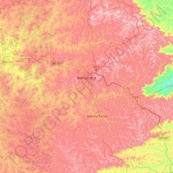
Name: Topografische Karte Barbacena, Höhe, Relief.
Durchschnittliche Höhe: 1.077 m
Minimale Höhe: 619 m
Maximale Höhe: 1.346 m
Andere topografische Karten
Klicken Sie auf eine Karte, um ihre Topografie, ihre Höhe und ihr Relief anzuzeigen.
Itajubá
Brasilien > Minas Gerais > Itajubá > Itajubá
Gegründet wurde die Stadt 1819 von Padre Lourenço da Costa Moreira als Vila de Boa Vista. Noch heute ist ein Hotel nach den damals ansässigen Coroados-Indios benannt. Der Name Itajubá kommt allerdings aus der Sprache der Tupí, in der Originalform itaîuba, übersetzt von der Höhe hinabfallender Fluss der…
Durchschnittliche Höhe: 923 m