
Topografische Karte Ľubotice
Interaktive Karte
Klicken Sie auf die Karte, um die Höhe anzuzeigen.
Ľubotice
The municipality lies at an elevation of 258 metres (846 ft) and covers an area of 8.324 km² (2,045 acres). It had a population of 3025 people in 2009.
Über diese Karte
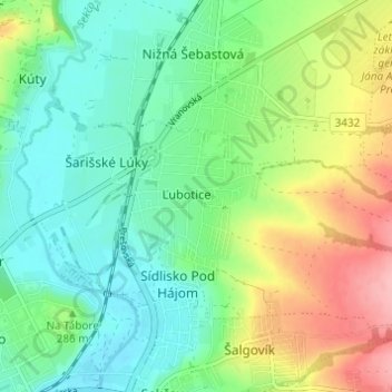
Name: Topografische Karte Ľubotice, Höhe, Relief.
Ort: Ľubotice, Region of Prešov, Eastern Slovakia, 080 06, Slovakia (48.99126 21.25648 49.03126 21.29648)
Durchschnittliche Höhe: 284 m
Minimale Höhe: 240 m
Maximale Höhe: 372 m