
Topografische Karte Kuvalettam
Klicken Sie auf die Karte, um die Höhe anzuzeigen.
Über diese Karte
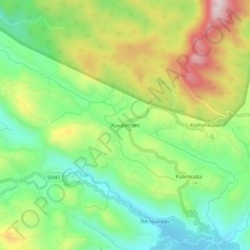
Name: Topografische Karte Kuvalettam, Höhe, Relief.
Ort: Kuvalettam, Peerumade, Idukki District, Kerala, 685503, India (9.69675 76.92894 9.73675 76.96894)
Durchschnittliche Höhe: 979 m
Minimale Höhe: 813 m
Maximale Höhe: 1.231 m
Andere topografische Karten
Klicken Sie auf eine Karte, um ihre Topografie, ihre Höhe und ihr Relief anzuzeigen.
Periyar National Park Tiger Reserve
Periyar National Park lies in the middle of a mountainous area of the Cardamom Hills. In the north : The boundary commences from the point nearest to the Medaganam in the interstate boundary up to Vellimalai. and the east Thence the boundary follows the inter-state boundary from Vellimalai to Kallimalai Peak…
Durchschnittliche Höhe: 929 m