
Topografische Karte Apponaug
Interaktive Karte
Klicken Sie auf die Karte, um die Höhe anzuzeigen.
Über diese Karte
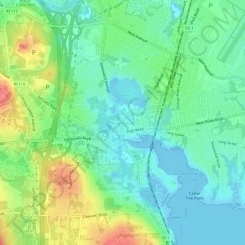
Name: Topografische Karte Apponaug, Höhe, Relief.
Ort: Apponaug, Kent County, Rhode Island, 02886, United States (41.68038 -71.47978 41.72038 -71.43978)
Durchschnittliche Höhe: 23 m
Minimale Höhe: -8 m
Maximale Höhe: 69 m
Andere topografische Karten
Klicken Sie auf eine Karte, um ihre Topografie, ihre Höhe und ihr Relief anzuzeigen.
Anthony
United States > Rhode Island > Kent County > Coventry
Anthony, Coventry, Kent County, Rhode Island, 02816, United States
Durchschnittliche Höhe: 71 m
East Greenwich
United States > Rhode Island > Kent County
East Greenwich, Kent County, Rhode Island, 02818, United States
Durchschnittliche Höhe: 21 m
Coventry
United States > Rhode Island > Kent County
Coventry, Kent County, Rhode Island, United States
Durchschnittliche Höhe: 126 m
Crompton
United States > Rhode Island > Kent County > West Warwick
Crompton, West Warwick, Kent County, Rhode Island, 02893, United States
Durchschnittliche Höhe: 63 m
West Greenwich
United States > Rhode Island > Kent County > West Greenwich
West Greenwich, Kent County, Rhode Island, 02817, United States
Durchschnittliche Höhe: 111 m
Warwick
United States > Rhode Island > Kent County
Warwick, Kent County, Rhode Island, United States
Durchschnittliche Höhe: 34 m