Geolokalisieren

Topografische Karte Yerres

Interaktive Karte

Klicken Sie auf die Karte, um die Höhe anzuzeigen.

Über diese Karte

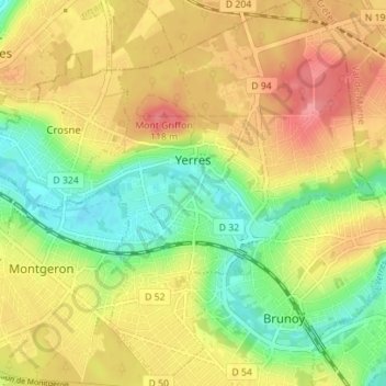
Name: Topografische Karte Yerres, Höhe, Relief.

Ort: Yerres, Arrondissement d'Évry, Essonne, Ile-de-France, Metropolitan France, 91330, France (48.68983 2.46541 48.73586 2.52097)

Durchschnittliche Höhe: 74 m

Minimale Höhe: 31 m

Maximale Höhe: 117 m

Yerres lies in the North-Eastern part of Essonne and bordering the Val-de-Marne département. The town extends on both sides of the valley through which flows the river Yerres. The highest point is the wooded Mont Griffon, which reaches an altitude of 116 m, while the lowest point is at only 30 m above sea level.

Wikipedia (CC-BY-SA 3.0)

Andere topografische Karten

Klicken Sie auf eine Karte, um ihre Topografie, ihre Höhe und ihr Relief anzuzeigen.

Ventoux

France > Ile-de-France > Essonne > Les Ulis

Ventoux, Les Ulis, Palaiseau, Essonne, Ile-de-France, Metropolitan France, 91940, France

Durchschnittliche Höhe: 154 m

Palaiseau

France > Ile-de-France > Essonne > Palaiseau

Palaiseau, Essonne, Ile-de-France, Metropolitan France, 91120, France

Durchschnittliche Höhe: 95 m

Saint-Sulpice-de-Favières

France > Ile-de-France > Essonne

Saint-Sulpice-de-Favières, Étampes, Essonne, Ile-de-France, Metropolitan France, 91910, France

Durchschnittliche Höhe: 130 m