
Topografische Karte Brooks Range
Interaktive Karte
Klicken Sie auf die Karte, um die Höhe anzuzeigen.
Über diese Karte
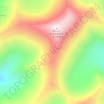
Name: Topografische Karte Brooks Range, Höhe, Relief.
Ort: Brooks Range, North Slope, Alaska, États-Unis d'Amérique (69.27135 -144.91375 69.27145 -144.91365)
Durchschnittliche Höhe: 2.115 m
Minimale Höhe: 1.578 m
Maximale Höhe: 2.720 m
Andere topografische Karten
Klicken Sie auf eine Karte, um ihre Topografie, ihre Höhe und ihr Relief anzuzeigen.
Point Barrow
États-Unis d'Amérique > Alaska > North Slope
Point Barrow, North Slope, Alaska, États-Unis d'Amérique
Durchschnittliche Höhe: 0 m
Point Lay
États-Unis d'Amérique > Alaska > North Slope
Point Lay, North Slope, Alaska, 99759, États-Unis d'Amérique
Durchschnittliche Höhe: 3 m