
Topografische Karte Knox County
Interaktive Karte
Klicken Sie auf die Karte, um die Höhe anzuzeigen.
Über diese Karte
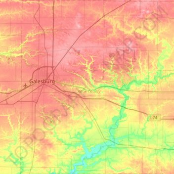
Name: Topografische Karte Knox County, Höhe, Relief.
Ort: Knox County, Illinois, USA (40.71143 -90.44663 41.15213 -89.98515)
Durchschnittliche Höhe: 219 m
Minimale Höhe: 161 m
Maximale Höhe: 268 m
Andere topografische Karten
Klicken Sie auf eine Karte, um ihre Topografie, ihre Höhe und ihr Relief anzuzeigen.
Vernon Hills
USA > Illinois > Vernon Hills
Vernon Hills, Lake County, Illinois, 60061, USA
Durchschnittliche Höhe: 219 m
Mount Carmel
USA > Illinois > Mount Carmel
Mount Carmel, Wabash County, Illinois, USA
Durchschnittliche Höhe: 128 m
Montague Island
Montague Island, Rockford, Winnebago County, Illinois, 61104, USA
Durchschnittliche Höhe: 254 m
Garfield Ridge
Garfield Ridge, Chicago, Cook County, Illinois, USA
Durchschnittliche Höhe: 184 m