
Topografische Karte Kofa National Wildlife Refuge
Interaktive Karte
Klicken Sie auf die Karte, um die Höhe anzuzeigen.
Über diese Karte
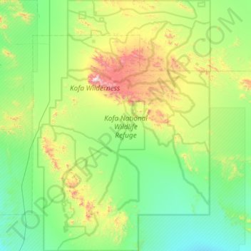
Name: Topografische Karte Kofa National Wildlife Refuge, Höhe, Relief.
Durchschnittliche Höhe: 460 m
Minimale Höhe: 151 m
Maximale Höhe: 1.439 m
Andere topografische Karten
Klicken Sie auf eine Karte, um ihre Topografie, ihre Höhe und ihr Relief anzuzeigen.
San Luis
United States > Arizona > Yuma County
San Luis, Yuma County, Arizona, United States
Durchschnittliche Höhe: 36 m
Araby
United States > Arizona > Yuma County > Yuma
Araby, Yuma, Yuma County, Arizona, 85365, United States
Durchschnittliche Höhe: 60 m
Palomas
United States > Arizona > Yuma County
Palomas, Yuma County, Arizona, United States
Durchschnittliche Höhe: 125 m
Hyder
United States > Arizona > Yuma County
Hyder, Yuma County, Arizona, 85333, United States
Durchschnittliche Höhe: 173 m
Dateland
United States > Arizona > Yuma County
Dateland, Yuma County, Arizona, United States
Durchschnittliche Höhe: 138 m
Somerton
United States > Arizona > Yuma County
Somerton, Yuma County, Arizona, 85350, United States
Durchschnittliche Höhe: 33 m
Buckshot
United States > Arizona > Yuma County
Buckshot, Yuma County, Arizona, United States
Durchschnittliche Höhe: 52 m
Fortuna Foothills
United States > Arizona > Yuma County
Fortuna Foothills, Yuma County, Arizona, United States
Durchschnittliche Höhe: 133 m
Yuma
United States > Arizona > Yuma County
Yuma, Yuma County, Arizona, United States
Durchschnittliche Höhe: 78 m
Noah
United States > Arizona > Yuma County
Noah, Yuma County, Arizona, United States
Durchschnittliche Höhe: 106 m
Tuscan Ranch
United States > Arizona > Yuma County > Yuma
Tuscan Ranch, Yuma, Yuma County, Arizona, United States
Durchschnittliche Höhe: 63 m
Wellton
United States > Arizona > Yuma County
Wellton, Yuma County, Arizona, United States
Durchschnittliche Höhe: 97 m
Laguna Mountains
United States > Arizona > Yuma County
Laguna Mountains, Yuma County, Arizona, United States
Durchschnittliche Höhe: 141 m