
Topografische Karte Wallonia
Interaktive Karte
Klicken Sie auf die Karte, um die Höhe anzuzeigen.
Über diese Karte
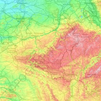
Name: Topografische Karte Wallonia, Höhe, Relief.
Ort: Wallonia, Belgium (49.49698 2.84203 50.81212 6.40810)
Durchschnittliche Höhe: 215 m
Minimale Höhe: -2 m
Maximale Höhe: 796 m
Wallonia is landlocked, with an area of 16,901 km2 (6,526 sq mi), or 55 percent of the total area of Belgium. The Sambre and Meuse valley, from Liège (70 m (230 ft)) to Charleroi (120 m (390 ft)) is an entrenched river in a fault line which separates Middle Belgium (elevation 100–200 m (330–660 ft)) and High Belgium (200–700 m (660–2,300 ft)). This fault line corresponds to a part of the southern coast of the late London-Brabant Massif. The valley, along with Haine and Vesdre valleys form the sillon industriel, the historical centre of the Belgian coalmining and steelmaking industry, and is also called the Walloon industrial backbone. Due to their long industrial historic record, several segments of the valley have received specific names: Borinage, around Mons, le Centre, around La Louvière, the Pays noir, around Charleroi and the Basse-Sambre, near Namur.
Andere topografische Karten
Klicken Sie auf eine Karte, um ihre Topografie, ihre Höhe und ihr Relief anzuzeigen.
Braine-le-Château
Belgium > Wallonia > Hameau du Pont
Braine-le-Château, Hameau du Pont, Nivelles, Walloon Brabant, Wallonia, 1440, Belgium
Durchschnittliche Höhe: 90 m
Chaudfontaine
Belgium > Wallonia > Chaudfontaine
Chaudfontaine, Liège, Wallonia, 4050, Belgium
Durchschnittliche Höhe: 188 m
Londerzeel
Belgium > Flanders > Londerzeel
Londerzeel, Halle-Vilvoorde, Flemish Brabant, Flanders, 1840, Belgium
Durchschnittliche Höhe: 10 m
Philippeville
Belgium > Wallonia > Philippeville
Philippeville, Namur, Wallonia, 5600, Belgium
Durchschnittliche Höhe: 229 m