
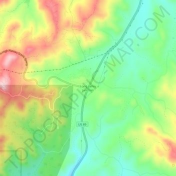
Topografische Karte Long Valley Junction
Interaktive Karte
Klicken Sie auf die Karte, um die Höhe anzuzeigen.
Über diese Karte
Name: Topografische Karte Long Valley Junction, Höhe, Relief.
Durchschnittliche Höhe: 2.295 m
Minimale Höhe: 2.193 m
Maximale Höhe: 2.440 m
Andere topografische Karten
Klicken Sie auf eine Karte, um ihre Topografie, ihre Höhe und ihr Relief anzuzeigen.
Navajo Lake
United States > Utah > Kane County > Navajo Lake Lodge
Navajo Lake, Navajo Lake Lodge, Kane County, Utah, United States
Durchschnittliche Höhe: 2.851 m
Coyote Gulch
United States > Utah > Kane County
Coyote Gulch, Kane County, Utah, United States
Durchschnittliche Höhe: 1.361 m
Lone Rock Beach
United States > Utah > Kane County
Lone Rock Beach, Kane County, Utah, United States
Durchschnittliche Höhe: 1.134 m
Spooky Gulch
United States > Utah > Kane County
Spooky Gulch, Kane County, Utah, United States
Durchschnittliche Höhe: 1.472 m
Cottonwood Point
United States > Utah > Kane County
Cottonwood Point, Kane County, Utah, United States
Durchschnittliche Höhe: 1.641 m