
Topografische Karte Animas
Interaktive Karte
Klicken Sie auf die Karte, um die Höhe anzuzeigen.
Über diese Karte
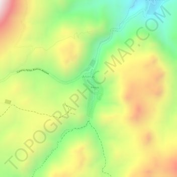
Name: Topografische Karte Animas, Höhe, Relief.
Ort: Animas, Municipio Atocha, Sur Chichas, Potosí, Bolivia (-20.96706 -66.30864 -20.95772 -66.30488)
Durchschnittliche Höhe: 4.280 m
Minimale Höhe: 3.981 m
Maximale Höhe: 4.583 m
Andere topografische Karten
Klicken Sie auf eine Karte, um ihre Topografie, ihre Höhe und ihr Relief anzuzeigen.
Siete Suyos
Bolivia > Potosí > Sur Chichas
Siete Suyos, Municipio Atocha, Sur Chichas, Potosí, Bolivia
Durchschnittliche Höhe: 4.159 m
Municipio Atocha
Bolivia > Potosí > Sur Chichas
Municipio Atocha, Sur Chichas, Potosí, Bolivia
Durchschnittliche Höhe: 4.039 m
Tatasi
Bolivia > Potosí > Sur Chichas
Tatasi, Municipio Atocha, Sur Chichas, Potosí, Bolivia
Durchschnittliche Höhe: 4.249 m
Tupiza
Bolivia > Potosí > Sur Chichas
Tupiza, Sur Chichas, Potosí, Bolivia
Durchschnittliche Höhe: 3.555 m
Telamayu
Bolivia > Potosí > Sur Chichas > Telamayu
Telamayu, Municipio Atocha, Sur Chichas, Potosí, Bolivia
Durchschnittliche Höhe: 3.742 m