
Topografische Karte Canyon de Chelly National Monument
Interaktive Karte
Klicken Sie auf die Karte, um die Höhe anzuzeigen.
Über diese Karte
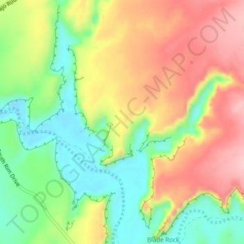
Name: Topografische Karte Canyon de Chelly National Monument, Höhe, Relief.
Durchschnittliche Höhe: 1.770 m
Minimale Höhe: 1.691 m
Maximale Höhe: 1.854 m
Andere topografische Karten
Klicken Sie auf eine Karte, um ihre Topografie, ihre Höhe und ihr Relief anzuzeigen.
Red Rock
United States > Arizona > Apache County
Red Rock, Shiprock Agency, Apache County, Arizona, United States
Durchschnittliche Höhe: 1.780 m
Sawmill
United States > Arizona > Apache County
Sawmill, Fort Defiance Agency, Apache County, Arizona, 86549, United States
Durchschnittliche Höhe: 2.354 m
St. Michaels
United States > Arizona > Apache County
St. Michaels, Fort Defiance Agency, Apache County, Arizona, 86511, United States
Durchschnittliche Höhe: 2.066 m
Concho
United States > Arizona > Apache County > Concho
Concho, Apache County, Arizona, 85914, United States
Durchschnittliche Höhe: 1.844 m
Eagle Crag
United States > Arizona > Apache County
Eagle Crag, Apache County, Arizona, United States
Durchschnittliche Höhe: 1.970 m
South Mountain
United States > Arizona > Apache County > Alpine
South Mountain, Alpine, Apache County, Arizona, 75920, United States
Durchschnittliche Höhe: 2.716 m
Petrified Forest National Park
United States > Arizona > Apache County
Petrified Forest National Park, Apache County, Arizona, 86028, United States
Durchschnittliche Höhe: 1.722 m
Teec Nos Pos
United States > Arizona > Apache County
Teec Nos Pos, Shiprock Agency, Apache County, Arizona, United States
Durchschnittliche Höhe: 1.620 m