
Topografische Karte Le Hohwald
Interaktive Karte
Klicken Sie auf die Karte, um die Höhe anzuzeigen.
Le Hohwald
Le Hohwald is a hill village, with altitude above sea level in the commune ranging from 450 meters to nearly 1100 meters, positioned some fifty kilometres to the west-south-west of Strasbourg and some ten kilometres to the south-west of Mont Sainte-Odile. Its position in the lee of mountains protects it from north winds and from many of the frequent fogs and mists that are a feature of the climate elsewhere in Alsace, and supports claims of an unexpectedly benign climate all the year round.
Über diese Karte
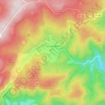
Name: Topografische Karte Le Hohwald, Höhe, Relief.
Durchschnittliche Höhe: 730 m
Minimale Höhe: 358 m
Maximale Höhe: 1.048 m
Andere topografische Karten
Klicken Sie auf eine Karte, um ihre Topografie, ihre Höhe und ihr Relief anzuzeigen.