
Spenden
Rüsten Sie sich für Ihr nächstes Abenteuer:
Als Amazon-Partner erhält diese Website eine Provision für qualifizierte Käufe, ohne zusätzliche Kosten für Sie.
Topografische Karte St. George
Klicken Sie auf die Karte, um die Höhe anzuzeigen.
Spenden
Rüsten Sie sich für Ihr nächstes Abenteuer:
Als Amazon-Partner erhält diese Website eine Provision für qualifizierte Käufe, ohne zusätzliche Kosten für Sie.
St. George
According to the United States Census Bureau, the city has an area of 77.151 square miles (199.82 km2), of which 0.003 square miles (0.0078 km2) (0.72% or about 2 ac) is covered by water. St. George is in a desert valley, with most of the city lying below 3,000 feet (900 m) in elevation. It is near a geological transition zone where the Colorado Plateau and Great Basin converge. The Beaver Dam Mountains/Utah Hill lie to the west, the Red Cliffs National Conservation Area and Pine Valley Mountains to the north, the western edge of the Colorado Plateau and Zion National Park to the east, and the Arizona Strip to the south. The Virgin River, the Santa Clara River, and the seasonal Fort Pearce Wash flow through the St. George valley and converge near the western base of Webb Hill near the city center.
Spenden
Rüsten Sie sich für Ihr nächstes Abenteuer:
Als Amazon-Partner erhält diese Website eine Provision für qualifizierte Käufe, ohne zusätzliche Kosten für Sie.
Über diese Karte
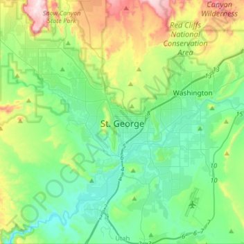
Name: Topografische Karte St. George, Höhe, Relief.
Ort: St. George, Washington County, Utah, United States (36.99997 -113.64976 37.21209 -113.47681)
Durchschnittliche Höhe: 933 m
Minimale Höhe: 729 m
Maximale Höhe: 1.497 m
Spenden
Rüsten Sie sich für Ihr nächstes Abenteuer:
Als Amazon-Partner erhält diese Website eine Provision für qualifizierte Käufe, ohne zusätzliche Kosten für Sie.
Andere topografische Karten
Klicken Sie auf eine Karte, um ihre Topografie, ihre Höhe und ihr Relief anzuzeigen.
Spenden
Rüsten Sie sich für Ihr nächstes Abenteuer:
Als Amazon-Partner erhält diese Website eine Provision für qualifizierte Käufe, ohne zusätzliche Kosten für Sie.
Zion Canyon
United States > Utah > Washington County
Geologically Zion Canyon is part of the Navajo sandstone Colorado Plateau, which contained many joints and cracks when first uplifted, one of which was cut by the North Fork of the Virgin River to become Zion Canyon. The river was the largest force in cutting the canyon, mostly by flash floods, as the average…
Durchschnittliche Höhe: 1.821 m
Anderson Junction
United States > Utah > Washington County > Toquerville
Durchschnittliche Höhe: 1.189 m
Spenden
Rüsten Sie sich für Ihr nächstes Abenteuer:
Als Amazon-Partner erhält diese Website eine Provision für qualifizierte Käufe, ohne zusätzliche Kosten für Sie.
Angels Landing
United States > Utah > Washington County
The trail to Angels Landing is 2.5 miles (4.0 km) long with an approximate 1,500 feet (460 m) elevation gain. The hike is rated as a class 3 difficulty based on the Yosemite Decimal System. It begins at the Grotto drop-off point on the park's shuttle system, which operates from early spring through late fall.…
Durchschnittliche Höhe: 1.695 m
Watchman Trailhead
United States > Utah > Washington County > Springdale
Durchschnittliche Höhe: 1.316 m