
Spenden
Rüsten Sie sich für Ihr nächstes Abenteuer:
Als Amazon-Partner erhält diese Website eine Provision für qualifizierte Käufe, ohne zusätzliche Kosten für Sie.
Topografische Karte Solvang
Klicken Sie auf die Karte, um die Höhe anzuzeigen.
Spenden
Rüsten Sie sich für Ihr nächstes Abenteuer:
Als Amazon-Partner erhält diese Website eine Provision für qualifizierte Käufe, ohne zusätzliche Kosten für Sie.
Solvang
Solvang is located at 34°35′38″N 120°8′23″W / 34.59389°N 120.13972°W / 34.59389; -120.13972. At an elevation of 505 ft (154 m), it lies in the Santa Ynez Valley some 46 miles (74 km) north-west of Santa Barbara and about 15 miles (24 km) north of the Pacific coast. According to the United States Census Bureau, the city has a total area of 2.4 square miles (6.2 km2), 99.95% of it land and 0.05% of it water.
Spenden
Rüsten Sie sich für Ihr nächstes Abenteuer:
Als Amazon-Partner erhält diese Website eine Provision für qualifizierte Käufe, ohne zusätzliche Kosten für Sie.
Über diese Karte
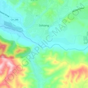
Name: Topografische Karte Solvang, Höhe, Relief.
Ort: Solvang, Santa Barbara County, California, United States (34.55889 -120.15491 34.61077 -120.11992)
Durchschnittliche Höhe: 194 m
Minimale Höhe: 102 m
Maximale Höhe: 442 m
Spenden
Rüsten Sie sich für Ihr nächstes Abenteuer:
Als Amazon-Partner erhält diese Website eine Provision für qualifizierte Käufe, ohne zusätzliche Kosten für Sie.
Andere topografische Karten
Klicken Sie auf eine Karte, um ihre Topografie, ihre Höhe und ihr Relief anzuzeigen.
Mission Canyon
United States > California > Santa Barbara County
The approximate center of Mission Canyon is located at 34°26′59″N 119°42′59″W / 34.44972°N 119.71639°W / 34.44972; -119.71639 (34.449797, -119.716315). Situated along the southern facing slopes of the Santa Ynez Mountains, Mission Canyon measures some 1,122 acres comprising an estimated…
Durchschnittliche Höhe: 199 m
Campus Lagoon
United States > California > Santa Barbara County > Isla Vista
Durchschnittliche Höhe: 5 m
Spenden
Rüsten Sie sich für Ihr nächstes Abenteuer:
Als Amazon-Partner erhält diese Website eine Provision für qualifizierte Käufe, ohne zusätzliche Kosten für Sie.
Santa Maria
United States > California > Santa Barbara County > Santa Maria
Durchschnittliche Höhe: 185 m
Spenden
Rüsten Sie sich für Ihr nächstes Abenteuer:
Als Amazon-Partner erhält diese Website eine Provision für qualifizierte Käufe, ohne zusätzliche Kosten für Sie.