
Topografische Karte Elatochori
Interaktive Karte
Klicken Sie auf die Karte, um die Höhe anzuzeigen.
Über diese Karte
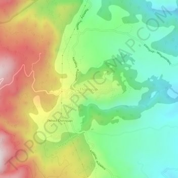
Name: Topografische Karte Elatochori, Höhe, Relief.
Durchschnittliche Höhe: 722 m
Minimale Höhe: 408 m
Maximale Höhe: 1.192 m
Elatochori is known for its ski center, which is located at an altitude of 1,400 to 1,800 meters (4,600 to 5,900 feet) on the southeastern slopes of the Pierian Mountains. At the base of the ski resort and at the location "Papá Choráfi", there is a dining room and a chalet with a total area of 450 sq.m. (4,840 sq.ft.) with a capacity of more than 400 people. It operated for the first time on a trial basis, in 2000, and officially in 2001. It is 8 km (5 miles) from the village and 36 km (22 miles) from the city of Katerini. The Ski Sports and Mountaineering Association operates in the Ski Center.
Andere topografische Karten
Klicken Sie auf eine Karte, um ihre Topografie, ihre Höhe und ihr Relief anzuzeigen.
Dion - Olympos Municipality
Greece > Macedonia and Thrace > Pieria Regional Unit
Dion - Olympos Municipality, Pieria Regional Unit, Central Macedonia, Macedonia and Thrace, Greece
Durchschnittliche Höhe: 629 m