
Topografische Karte Belvidere
Interaktive Karte
Klicken Sie auf die Karte, um die Höhe anzuzeigen.
Über diese Karte
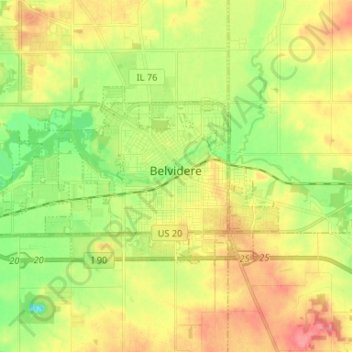
Name: Topografische Karte Belvidere, Höhe, Relief.
Durchschnittliche Höhe: 244 m
Minimale Höhe: 208 m
Maximale Höhe: 282 m
Belvidere developed on both sides of the Kishwaukee River in north central Illinois. It is 76 miles from downtown Chicago on Routes 20, 76 and the Northern Illinois Toll road. Belvidere is an industrial community surrounded by prosperous farms. It is the County Seat with an estimated 2006 county population of over 52,000. The altitude is 800 feet above sea level, average temperatures are: 73 degrees F in the summer; 24 degrees F in the winter, and the average rainfall is 33.3 inches, and the average annual snowfall is 35.3 inches.
Andere topografische Karten
Klicken Sie auf eine Karte, um ihre Topografie, ihre Höhe und ihr Relief anzuzeigen.
Caledonia Township
United States > Illinois > Boone County
Caledonia Township, Boone County, Illinois, United States
Durchschnittliche Höhe: 280 m
Poplar Grove Township
United States > Illinois > Boone County
Poplar Grove Township, Boone County, Illinois, 61065, United States
Durchschnittliche Höhe: 273 m
Caledonia
United States > Illinois > Boone County
Caledonia, Caledonia Township, Boone County, Illinois, United States
Durchschnittliche Höhe: 284 m