
Spenden
Rüsten Sie sich für Ihr nächstes Abenteuer:
Als Amazon-Partner erhält diese Website eine Provision für qualifizierte Käufe, ohne zusätzliche Kosten für Sie.
Topografische Karte Sawantwadi
Klicken Sie auf die Karte, um die Höhe anzuzeigen.
Spenden
Rüsten Sie sich für Ihr nächstes Abenteuer:
Als Amazon-Partner erhält diese Website eine Provision für qualifizierte Käufe, ohne zusätzliche Kosten für Sie.
Sawantwadi
Sawantwadi is located at 16°00′N 73°45′E / 16°N 73.75°E / 16; 73.75 in the Sindhudurg district of Maharashtra. It has an average elevation of 22 metres (72 ft) above mean sea level. It is the administrative headquarters of the Sindhudurg district. Sawantwadi is situated on the west coast of Maharashtra, India, and is bounded by the Arabian Sea to its west and the Western Ghats to its east. As a municipal entity, it spans an area of 132.45 km2 (51.14 sq mi), and experiences moderate to gusty winds during the day and gentle winds at night. The topography of the city ranges from plain to undulating, with several hills, valleys and flat areas within the city. The geology of the city is characterised by hard laterite in hilly tracts and sandy soil along the seashore.
Spenden
Rüsten Sie sich für Ihr nächstes Abenteuer:
Als Amazon-Partner erhält diese Website eine Provision für qualifizierte Käufe, ohne zusätzliche Kosten für Sie.
Über diese Karte
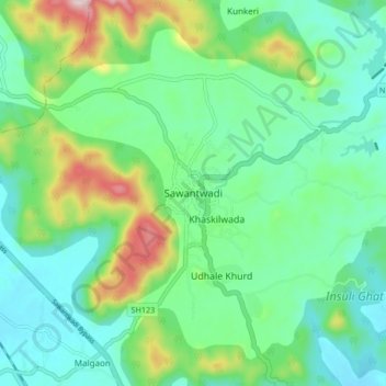
Name: Topografische Karte Sawantwadi, Höhe, Relief.
Durchschnittliche Höhe: 116 m
Minimale Höhe: 19 m
Maximale Höhe: 380 m
Spenden
Rüsten Sie sich für Ihr nächstes Abenteuer:
Als Amazon-Partner erhält diese Website eine Provision für qualifizierte Käufe, ohne zusätzliche Kosten für Sie.