
Topografische Karte Cowley County
Interaktive Karte
Klicken Sie auf die Karte, um die Höhe anzuzeigen.
Über diese Karte
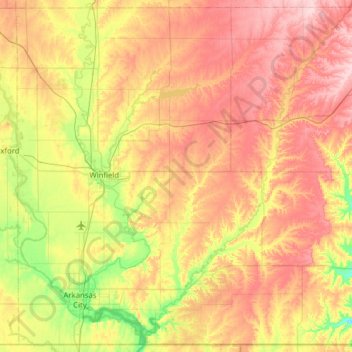
Name: Topografische Karte Cowley County, Höhe, Relief.
Ort: Cowley County, Kansas, États-Unis d'Amérique (36.99886 -97.15142 37.47692 -96.52615)
Durchschnittliche Höhe: 382 m
Minimale Höhe: 295 m
Maximale Höhe: 474 m
Andere topografische Karten
Klicken Sie auf eine Karte, um ihre Topografie, ihre Höhe und ihr Relief anzuzeigen.
Ramona
États-Unis d'Amérique > Kansas > Marion County
Ramona, Marion County, Kansas, 67475, États-Unis d'Amérique
Durchschnittliche Höhe: 435 m
St. John
États-Unis d'Amérique > Kansas > Stafford County
St. John, Stafford County, Kansas, 67576, États-Unis d'Amérique
Durchschnittliche Höhe: 581 m
Leavenworth County
États-Unis d'Amérique > Kansas > Leavenworth County
Leavenworth County, Kansas, États-Unis d'Amérique
Durchschnittliche Höhe: 290 m
Coats
États-Unis d'Amérique > Kansas > Pratt County
Coats, Pratt County, Kansas, États-Unis d'Amérique
Durchschnittliche Höhe: 603 m
Graham County
États-Unis d'Amérique > Kansas > Graham County
Graham County, Kansas, États-Unis d'Amérique
Durchschnittliche Höhe: 720 m
Gray County
États-Unis d'Amérique > Kansas
Gray County, Kansas, États-Unis d'Amérique
Durchschnittliche Höhe: 837 m