Geolokalisieren

Topografische Karte Paradeep Lock

Klicken Sie auf die Karte, um die Höhe anzuzeigen.

👉 Easily get elevation data in JSON, GeoTIFF and KML formats using Elevation API
Vielen Dank für die Unterstützung dieser Website ❤️
Spenden

Rüsten Sie sich für Ihr nächstes Abenteuer:

Als Amazon-Partner erhält diese Website eine Provision für qualifizierte Käufe, ohne zusätzliche Kosten für Sie.

Über diese Karte

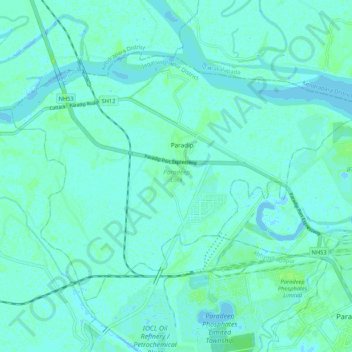
Name: Topografische Karte Paradeep Lock, Höhe, Relief.

Ort: Paradeep Lock, Jagatsinghapur District, Odisha, India (20.27190 86.55808 20.34183 86.66378)

Durchschnittliche Höhe: 3 m

Minimale Höhe: -6 m

Maximale Höhe: 9 m

Andere topografische Karten

Klicken Sie auf eine Karte, um ihre Topografie, ihre Höhe und ihr Relief anzuzeigen.

Bhubaneshwar

India > Odisha > Bhubaneswar (M.Corp.)

Bhubaneswar is in Khordha district of Odisha. It is in the eastern coastal plains, along the axis of the Eastern Ghats mountains. The city has an average altitude of 45 m (148 ft) above sea level. It lies southwest of the Mahanadi River that forms the northern boundary of Bhubaneswar metropolitan area, within…

Durchschnittliche Höhe: 30 m

Cuttack

India > Odisha > Cuttack (M.Corp.) P.S

Cuttack is located at 20°31′23″N 085°47′17″E / 20.52306°N 85.78806°E / 20.52306; 85.78806 and has an average elevation of 36 metres (118 ft). The city is spread across an area of 192.5 km2 (74 sq mi). The city, being a Cuttack Municipal Corporation which consists of 59 wards. The city…

Durchschnittliche Höhe: 34 m

Keonjhar

India > Odisha

Durchschnittliche Höhe: 301 m

Bhubaneshwar

India > Odisha > Bhubaneswar (M.Corp.)

Bhubaneswar is in Khordha district of Odisha. It is in the eastern coastal plains, along the axis of the Eastern Ghats mountains. The city has an average altitude of 45 m (148 ft) above sea level. It lies southwest of the Mahanadi River that forms the northern boundary of Bhubaneswar metropolitan area, within…

Durchschnittliche Höhe: 30 m

Sambalpur

India > Odisha

Durchschnittliche Höhe: 228 m

Kālāhandi

India > Odisha

Durchschnittliche Höhe: 452 m

Laxmipur

India > Odisha > Chhatrapur

Durchschnittliche Höhe: 27 m

Barkul

India > Odisha > Balugaon

Durchschnittliche Höhe: 12 m

Vielen Dank für die Unterstützung dieser Website ❤️
Spenden

Rüsten Sie sich für Ihr nächstes Abenteuer:

Als Amazon-Partner erhält diese Website eine Provision für qualifizierte Käufe, ohne zusätzliche Kosten für Sie.

Kamakhyanagar

India > Odisha > Kamakshyanagar

Durchschnittliche Höhe: 65 m

Dhauli

India > Odisha > Uttara P.S

Durchschnittliche Höhe: 15 m

Kalamidadar

India > Odisha > Nuapada

Durchschnittliche Höhe: 379 m

Mahendragiri

India > Odisha > Ramagiri > Burakhat

Mahendragiri, is a mountain in Rayagada block of the district of Gajapati, Odisha, India. It is situated amongst the Eastern Ghats at an elevation of 1,501 metres (4,925 ft). The second highest motorable mountain of Odisha and 8th highest peak of Odisha.

Durchschnittliche Höhe: 1.108 m

Vielen Dank für die Unterstützung dieser Website ❤️
Spenden

Rüsten Sie sich für Ihr nächstes Abenteuer:

Als Amazon-Partner erhält diese Website eine Provision für qualifizierte Käufe, ohne zusätzliche Kosten für Sie.

Umerkote

India > Odisha > Umarkote

Durchschnittliche Höhe: 613 m

Rourkela

India > Odisha > Raurkela (M)

Rourkela is located at 84.54E longitude and 22.12N latitude in Sundergarh district of Odisha at an elevation of about 219 m (719 ft) above mean sea level. The area of Rourkela is 200 square kilometers approximately. Being situated on the Howrah-Mumbai rail track, Rourkela had an added advantage of the steel…

Durchschnittliche Höhe: 237 m

Balachandrapur

India > Odisha > Balichandrapur

Durchschnittliche Höhe: 18 m

Balangir

India > Odisha

Durchschnittliche Höhe: 262 m

Eastern Ghats

India > Odisha > Ramagiri > Burakhat

The Eastern Ghats is a mountain range that stretches 1,750 km (1,090 mi) along the eastern coast of the Indian peninsula. Covering an area of 75,000 km2 (29,000 sq mi), it traverses the states of Odisha, Telangana, Andhra Pradesh, Karnataka, and Tamil Nadu. The range forms a discontinuous chain of mountains…

Durchschnittliche Höhe: 1.130 m

Rajput

India > Odisha > Bhairabsingipur

Durchschnittliche Höhe: 665 m

Arjunda

India > Odisha > Bheden

Durchschnittliche Höhe: 143 m

Lahanda

India > Odisha > Attabira

Durchschnittliche Höhe: 181 m

Jaugada

India > Odisha > Kabisuryanagar > Nuagaon

Durchschnittliche Höhe: 22 m

Paradip

India > Odisha > Paradeep Lock

Durchschnittliche Höhe: 3 m

Bari

India > Odisha > Bari - Ramachandrapur

Durchschnittliche Höhe: 12 m

Kirtipur

India > Odisha > Rangeilunda

Durchschnittliche Höhe: 7 m

Vielen Dank für die Unterstützung dieser Website ❤️
Spenden

Rüsten Sie sich für Ihr nächstes Abenteuer:

Als Amazon-Partner erhält diese Website eine Provision für qualifizierte Käufe, ohne zusätzliche Kosten für Sie.

Dumarpali

India > Odisha > Bargarh Sadar

Durchschnittliche Höhe: 172 m

Titlagarh

India > Odisha > Titlagarh

Titilagarh is located at 20°18′N 83°09′E / 20.3°N 83.15°E / 20.3; 83.15. It has an average elevation of 215 metres (705 feet).

Durchschnittliche Höhe: 210 m

Mangriguda

India > Odisha > Jeypore > Teliguda

Durchschnittliche Höhe: 587 m

Ambaguda

India > Odisha > Similiguda > P Ambaguda

Durchschnittliche Höhe: 899 m

Udaygiri

India > Odisha > Mathili

Durchschnittliche Höhe: 260 m

Chandeswar

India > Odisha > Tangi

Durchschnittliche Höhe: 18 m

Abdul Kalam Island

India > Odisha > Rajnagar

In May 2013, increasing concern has been drawn to the change of the island's topography, owing to sand erosion. Since the island is technically a shoal, seawater frequently causes sand-shifting. The DRDO sought the assistance of geological experts from National Institute of Ocean Technology to monitor the…

Durchschnittliche Höhe: 1 m

Sankhai

India > Odisha > Rasol

Durchschnittliche Höhe: 107 m

Vielen Dank für die Unterstützung dieser Website ❤️
Spenden

Rüsten Sie sich für Ihr nächstes Abenteuer:

Als Amazon-Partner erhält diese Website eine Provision für qualifizierte Käufe, ohne zusätzliche Kosten für Sie.

Narendrapur

India > Odisha > Chhatrapur

Durchschnittliche Höhe: 27 m

Khariaguda

India > Odisha > Jarada

Durchschnittliche Höhe: 72 m

Daincha

India > Odisha > Rairakhol

Durchschnittliche Höhe: 241 m

Tirtol

India > Odisha > Tirtol

Durchschnittliche Höhe: 8 m

Vielen Dank für die Unterstützung dieser Website ❤️
Spenden

Pipili

India > Odisha > Pipili

Pipili is located at 20°07′N 85°50′E / 20.12°N 85.83°E / 20.12; 85.83. It has an average elevation of 25 metres (82 feet).

Durchschnittliche Höhe: 12 m

Barabukra Falls

India > Odisha > Ambabhona

Durchschnittliche Höhe: 326 m

Chamakhandi

India > Odisha > Chhatrapur

Durchschnittliche Höhe: 40 m

Gunupur

India > Odisha > Gunupur

Durchschnittliche Höhe: 133 m

Rourkela

India > Odisha > Raurkela (M)

Rourkela is located at 84.54E longitude and 22.12N latitude in Sundergarh district of Odisha at an elevation of about 219 m (719 ft) above mean sea level. The area of Rourkela is 200 square kilometers approximately. Being situated on the Howrah-Mumbai rail track, Rourkela had an added advantage of the steel…

Durchschnittliche Höhe: 237 m

Kirtipur

India > Odisha > Rangeilunda

Durchschnittliche Höhe: 7 m

Angul

India > Odisha > Anugul

Angul (also known as Anugul) is a town and a municipality and the headquarters of Angul district in the state of Odisha, India. Angul has an average elevation of 195 m (640 ft) above sea level. The total geographical area of the district is 6232 km2. From the point of view of area, it stands 11th among the 30…

Durchschnittliche Höhe: 121 m

Kapilash WLS

India > Odisha > Gandia

Durchschnittliche Höhe: 94 m

Chandikhol

India > Odisha > Dharmasala

Durchschnittliche Höhe: 33 m

Phulbani

India > Odisha > Phulabani Town

Phulbani is located at 20°28′N 84°14′E / 20.47°N 84.23°E / 20.47; 84.23. It has an average elevation of 485 metres (1591 feet).

Durchschnittliche Höhe: 519 m

Jatani

India > Odisha > Jatani

Durchschnittliche Höhe: 26 m

Keonjhar

India > Odisha

Durchschnittliche Höhe: 301 m

Puri

India > Odisha > Puri (M)

Durchschnittliche Höhe: 6 m

Dharuadihi

India > Odisha > Dharuadihi

Durchschnittliche Höhe: 250 m

Vielen Dank für die Unterstützung dieser Website ❤️
Spenden

Rimuli

India > Odisha > Champua

Durchschnittliche Höhe: 399 m

Athagad

India > Odisha > Athagad

Durchschnittliche Höhe: 49 m

Gandhamardhan hill

India > Odisha > Khaprakhol

Durchschnittliche Höhe: 792 m

Hinjilicut

India > Odisha > Hinjili

Durchschnittliche Höhe: 34 m

Vielen Dank für die Unterstützung dieser Website ❤️
Spenden

Rüsten Sie sich für Ihr nächstes Abenteuer:

Als Amazon-Partner erhält diese Website eine Provision für qualifizierte Käufe, ohne zusätzliche Kosten für Sie.

Hirakud

India > Odisha > Hirakud

Durchschnittliche Höhe: 163 m

Katapali

India > Odisha > Bargarh

Durchschnittliche Höhe: 178 m

Brahmani River

India > Odisha > Rajnagar

Durchschnittliche Höhe: 3 m

Jharigaon

India > Odisha > Jharigan

Durchschnittliche Höhe: 616 m

Chandrabhaga

India > Odisha > Konark > Konark

Durchschnittliche Höhe: 6 m

Hatigarh

India > Odisha > Raibania

Durchschnittliche Höhe: 27 m

Sendha

India > Odisha > Kundheigola

Durchschnittliche Höhe: 116 m

Bhawanipatna

India > Odisha > Sadar

Durchschnittliche Höhe: 266 m

Gotma

India > Odisha > Jonk

Durchschnittliche Höhe: 322 m

Jatani

India > Odisha > Jatani

Jatani is located at 20°05′N 85°25′E / 20.09°N 85.42°E / 20.09; 85.42. It has an average elevation of 36 metres (118 feet).

Durchschnittliche Höhe: 26 m

Kumuli

India > Odisha > Bhairabsingipur

Durchschnittliche Höhe: 580 m

Brahmapur

India > Odisha > Rangeilunda

Durchschnittliche Höhe: 56 m

Pucci

India > Odisha > Koraput

Durchschnittliche Höhe: 884 m

Jhilminda

India > Odisha > Attabira

Durchschnittliche Höhe: 148 m

Pathara

India > Odisha > Rangeilunda

Durchschnittliche Höhe: 16 m

Bolagarh

India > Odisha > Bolagad

Durchschnittliche Höhe: 91 m

Vielen Dank für die Unterstützung dieser Website ❤️
Spenden

Rüsten Sie sich für Ihr nächstes Abenteuer:

Als Amazon-Partner erhält diese Website eine Provision für qualifizierte Käufe, ohne zusätzliche Kosten für Sie.

Bolagad

India > Odisha > Bolagad

Durchschnittliche Höhe: 93 m

Sundargarh

India > Odisha

Durchschnittliche Höhe: 370 m

Gobindapur

India > Odisha > Kabisuryanagar

Durchschnittliche Höhe: 25 m

Gopalpur

India > Odisha > Rangeilunda

Durchschnittliche Höhe: 11 m

Shreekhetra Vihar

India > Odisha > Khandagiri

Durchschnittliche Höhe: 38 m

Baripada

India > Odisha > Baripada (M)

Baripada is at 21°56′N 86°43′E / 21.94°N 86.72°E / 21.94; 86.72. It has an average elevation of 36 metres (118 feet). The city lies along the Budhabalanga River.

Durchschnittliche Höhe: 41 m

Sunabeda

India > Odisha > Sunabeda

Durchschnittliche Höhe: 887 m

Dumalpali

India > Odisha > Bhatli

Durchschnittliche Höhe: 207 m

Vielen Dank für die Unterstützung dieser Website ❤️
Spenden

Rüsten Sie sich für Ihr nächstes Abenteuer:

Als Amazon-Partner erhält diese Website eine Provision für qualifizierte Käufe, ohne zusätzliche Kosten für Sie.

Tentulia

India > Odisha > Berhampur > Tentulia

Durchschnittliche Höhe: 133 m

Borigumma

India > Odisha > Boriguma

Durchschnittliche Höhe: 605 m

Deogarh

India > Odisha > Debagarh

Durchschnittliche Höhe: 220 m

Vielen Dank für die Unterstützung dieser Website ❤️
Spenden

Rüsten Sie sich für Ihr nächstes Abenteuer:

Als Amazon-Partner erhält diese Website eine Provision für qualifizierte Käufe, ohne zusätzliche Kosten für Sie.

Rengali

India > Odisha > Rengali

Durchschnittliche Höhe: 212 m

Jharpokharia

India > Odisha > Jharpokharia

Durchschnittliche Höhe: 94 m

Brahmapalli

India > Odisha > Rangeilunda

Durchschnittliche Höhe: 12 m

Grinjel

India > Odisha > Sohela

Durchschnittliche Höhe: 230 m

Markandi

India > Odisha > Rangeilunda

Durchschnittliche Höhe: 5 m

Kanpur

India > Odisha > Kanpur

Durchschnittliche Höhe: 55 m

Jata Mundia

India > Odisha > Banki

Durchschnittliche Höhe: 35 m

Mahendragiri

India > Odisha > Ramagiri > Burakhat

Mahendragiri, is a mountain in Rayagada block of the district of Gajapati, Odisha, India. It is situated amongst the Eastern Ghats at an elevation of 1,501 metres (4,925 ft). The second highest mountain of Odisha.

Durchschnittliche Höhe: 1.108 m

Narasinghpur

India > Odisha > Narasinghpur

Durchschnittliche Höhe: 74 m

Tarbha

India > Odisha > Tarbha

Durchschnittliche Höhe: 132 m

Pitapali

India > Odisha > Jatani

Durchschnittliche Höhe: 38 m

Khurdha Municipality Boundary

India > Odisha > Khordha

Durchschnittliche Höhe: 59 m

Vielen Dank für die Unterstützung dieser Website ❤️
Spenden

Rüsten Sie sich für Ihr nächstes Abenteuer:

Als Amazon-Partner erhält diese Website eine Provision für qualifizierte Käufe, ohne zusätzliche Kosten für Sie.

Puri

India > Odisha > Puri (M)

Durchschnittliche Höhe: 6 m

Khurdha Municipality Boundary

India > Odisha > Khordha

Durchschnittliche Höhe: 59 m

Gunupur

India > Odisha > Gunupur

Durchschnittliche Höhe: 133 m

Patnagarh

India > Odisha > Patnagarh

Durchschnittliche Höhe: 247 m

Vielen Dank für die Unterstützung dieser Website ❤️
Spenden

Rüsten Sie sich für Ihr nächstes Abenteuer:

🔭Nachtsichtgeräte - Beobachtung der Natur nach Sonnenuntergang
🛁Mikrofaser-Handtücher - Extrem leicht und schnelltrocknend für Trekkingtouren
🎒Rucksack Taschen Zubehör - Organizer‑Taschen für Rucksackinnenraum
🧥Regenjacke fürs Wandern - Wasserdichte Jacke mit Atmungsaktivität
🍲Camping-Kochsets - Platzsparendes Geschirr für die Outdoorküche

Als Amazon-Partner erhält diese Website eine Provision für qualifizierte Käufe, ohne zusätzliche Kosten für Sie.