
Topografische Karte Christopher
Interaktive Karte
Klicken Sie auf die Karte, um die Höhe anzuzeigen.
Über diese Karte
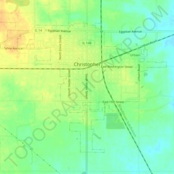
Name: Topografische Karte Christopher, Höhe, Relief.
Ort: Christopher, Franklin County, Illinois, 62822, United States (37.95400 -89.07863 37.98141 -89.03230)
Durchschnittliche Höhe: 130 m
Minimale Höhe: 116 m
Maximale Höhe: 145 m
Andere topografische Karten
Klicken Sie auf eine Karte, um ihre Topografie, ihre Höhe und ihr Relief anzuzeigen.
Benton Park
United States > Illinois > Franklin County > Benton
Benton Park, Benton, Franklin County, Illinois, 62897, United States
Durchschnittliche Höhe: 138 m
Benton
United States > Illinois > Franklin County
Benton, Franklin County, Illinois, 62812, United States
Durchschnittliche Höhe: 132 m
West Frankfort
United States > Illinois > Franklin County
West Frankfort, Franklin County, Illinois, 62896, United States
Durchschnittliche Höhe: 122 m
Thompsonville
United States > Illinois > Franklin County
Thompsonville, Franklin County, Illinois, United States
Durchschnittliche Höhe: 147 m
Royalton
United States > Illinois > Franklin County > Royalton
Royalton, Franklin County, Illinois, United States
Durchschnittliche Höhe: 122 m
Rend Lake
United States > Illinois > Franklin County
Rend Lake, Franklin County, Illinois, United States
Durchschnittliche Höhe: 132 m