
Topografische Karte Yantai
Interaktive Karte
Klicken Sie auf die Karte, um die Höhe anzuzeigen.
Über diese Karte
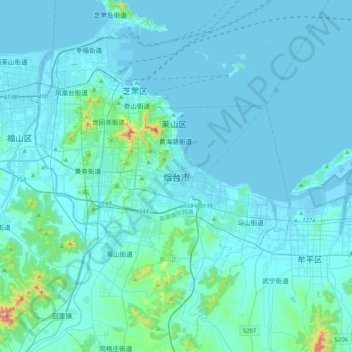
Name: Topografische Karte Yantai, Höhe, Relief.
Durchschnittliche Höhe: 34 m
Minimale Höhe: -3 m
Maximale Höhe: 546 m
Yantai is located along the north coast of the Shandong Peninsula, south of the junction of Bohai Sea and Yellow Sea and parallel to the southern coast of Liaoning. The topographical breakdown consists of: