
Topografische Karte Shennongjia
Interaktive Karte
Klicken Sie auf die Karte, um die Höhe anzuzeigen.
Über diese Karte
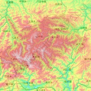
Name: Topografische Karte Shennongjia, Höhe, Relief.
Ort: Shennongjia, Hubei, China (31.29862 109.93621 31.86261 110.97283)
Durchschnittliche Höhe: 1.280 m
Minimale Höhe: 140 m
Maximale Höhe: 3.067 m
Shennongjia Forestry District is named after the Shennongjia mountainous massif, which is usually considered to be the eastern (and the highest) section of the Daba Mountains (Daba Shan). It lies within the Daba Mountains evergreen forests ecoregion. Some of Hubei's highest mountains - which are also the highest mountains of the Daba Shan - are located within the district. The three tallest peaks, located west of Muyu town, are Shennong Deng (3,105 metres (10,187 ft) elevation), Da Shennongjia (3,052 metres (10,013 ft)), and Xiao Shennongjia (3,005 metres (9,859 ft), on the border with Badong County). Laojun Shan, 2,936 metres (9,633 ft) tall, is located northeast of Muyu.
Andere topografische Karten
Klicken Sie auf eine Karte, um ihre Topografie, ihre Höhe und ihr Relief anzuzeigen.
Xiaowan Subdistrict
Xiaowan Subdistrict, Xiangzhou District, Xiangyang, Hubei, China
Durchschnittliche Höhe: 79 m
Huolongping
China > Hubei > Xianfeng County
Huolongping, Xianfeng County, Enshi Tujia and Miao Autonomous Prefecture, Hubei, 445600, China
Durchschnittliche Höhe: 914 m
Wuhan Botanical Garden, Chinese Academy of Sciences
China > Hubei > Hongshan District
Wuhan Botanical Garden, Chinese Academy of Sciences, 东湖生态旅游风景区(托管), Hongshan District, Wuhan, Hubei, 430074, China
Durchschnittliche Höhe: 29 m
Huanggang
China > Hubei > Huangmei County > Huanggang
Huanggang, Huangmei County, Hubei, China
Durchschnittliche Höhe: 75 m
Jiang'an District
China > Hubei > Jiang'an District
Jiang'an District, Hubei, 430062, China
Durchschnittliche Höhe: 25 m
Changyang Tujia Autonomous County
China > Hubei > Changyang Tujia Autonomous County
Changyang Tujia Autonomous County, Yichang, Hubei, China
Durchschnittliche Höhe: 483 m
Gucheng Subdistrict
China > Hubei > Xiangyang > Gucheng Subdistrict
Gucheng Subdistrict, Xiangcheng District, Xiangyang, Hubei, China
Durchschnittliche Höhe: 68 m
Three Gorges Dam
China > Hubei > Yichang > Sandouping
Three Gorges Dam, Sandouping, Yichang, Yiling District, Hubei, China
Durchschnittliche Höhe: 96 m
Sandouping
China > Hubei > Yichang > Sandouping
Sandouping, Yiling District, Yichang, Hubei, China
Durchschnittliche Höhe: 259 m
Xiling District
China > Hubei > Xiling District
Xiling District, Yichang, Hubei, 443005, China
Durchschnittliche Höhe: 232 m
Xianning City
China > Hubei > Xianning City
Xianning, Xian'an District, Xianning City, Hubei, China
Durchschnittliche Höhe: 90 m