
Topografische Karte Gahardu
Interaktive Karte
Klicken Sie auf die Karte, um die Höhe anzuzeigen.
Über diese Karte
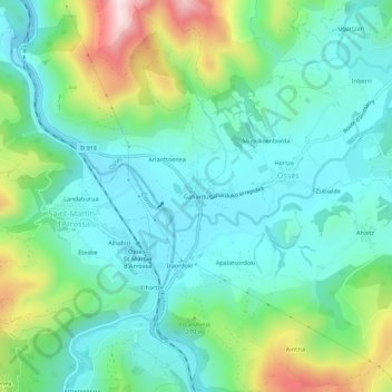
Name: Topografische Karte Gahardu, Höhe, Relief.
Durchschnittliche Höhe: 208 m
Minimale Höhe: 85 m
Maximale Höhe: 555 m
Andere topografische Karten
Klicken Sie auf eine Karte, um ihre Topografie, ihre Höhe und ihr Relief anzuzeigen.
Mutxikoenborda
France > Nouvelle-Aquitaine > Pyrénées-Atlantiques > Ossès
Mutxikoenborda, Ossès, Bayonne, Pyrénées-Atlantiques, Nouvelle-Aquitaine, France métropolitaine, 64780, France
Durchschnittliche Höhe: 218 m
Harizmendia
France > Nouvelle-Aquitaine > Pyrénées-Atlantiques > Ossès
Harizmendia, Ossès, Bayonne, Pyrénées-Atlantiques, Nouvelle-Aquitaine, France métropolitaine, 64780, France
Durchschnittliche Höhe: 215 m
Ugartzan
France > Nouvelle-Aquitaine > Pyrénées-Atlantiques > Ossès
Ugartzan, Ossès, Bayonne, Pyrénées-Atlantiques, Nouvelle-Aquitaine, France métropolitaine, 64780, France
Durchschnittliche Höhe: 258 m
Iriberri
France > Nouvelle-Aquitaine > Pyrénées-Atlantiques > Ossès
Iriberri, Ossès, Bayonne, Pyrénées-Atlantiques, Nouvelle-Aquitaine, France métropolitaine, 64780, France
Durchschnittliche Höhe: 225 m
Hortza
France > Nouvelle-Aquitaine > Pyrénées-Atlantiques > Ossès
Hortza, Ossès, Bayonne, Pyrénées-Atlantiques, Nouvelle-Aquitaine, France métropolitaine, 64780, France
Durchschnittliche Höhe: 211 m
Ahaitz
France > Nouvelle-Aquitaine > Pyrénées-Atlantiques > Ossès
Ahaitz, Ossès, Bayonne, Pyrénées-Atlantiques, Nouvelle-Aquitaine, France métropolitaine, 64780, France
Durchschnittliche Höhe: 231 m