
Topografische Karte Ioannina
Interaktive Karte
Klicken Sie auf die Karte, um die Höhe anzuzeigen.
Über diese Karte
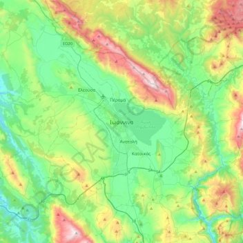
Name: Topografische Karte Ioannina, Höhe, Relief.
Durchschnittliche Höhe: 724 m
Minimale Höhe: 270 m
Maximale Höhe: 1.804 m
Ioannina (Greek: Ιωάννινα Ioánnina (listen)), often called Yannena (Γιάννενα Yánnena ) within Greece, is the capital and largest city of the Ioannina regional unit and of Epirus, an administrative region in north-western Greece. According to the 2011 census, the city population was 65,574, while the municipality had 112,486 inhabitants. It lies at an elevation of approximately 500 metres (1,640 feet) above sea level, on the western shore of lake Pamvotis (Παμβώτις). Ioannina is located 410 km (255 mi) northwest of Athens, 260 kilometres (162 miles) southwest of Thessaloniki and 80 km (50 miles) east of the port of Igoumenitsa in the Ionian Sea.