
Topografische Karte La Cambreta
Interaktive Karte
Klicken Sie auf die Karte, um die Höhe anzuzeigen.
Über diese Karte
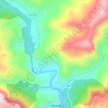
Name: Topografische Karte La Cambreta, Höhe, Relief.
Durchschnittliche Höhe: 760 m
Minimale Höhe: 582 m
Maximale Höhe: 1.032 m
Andere topografische Karten
Klicken Sie auf eine Karte, um ihre Topografie, ihre Höhe und ihr Relief anzuzeigen.
El Contador
España > Comunidad Valenciana > Castellón > Villahermosa del Río
El Contador, Villahermosa del Río, El Alto Mijares, Castellón, Comunidad Valenciana, España
Durchschnittliche Höhe: 1.191 m
Villahermosa del Río
España > Comunidad Valenciana > Castellón > Villahermosa del Río
Villahermosa del Río, El Alto Mijares, Castellón, Comunidad Valenciana, 12124, España
Durchschnittliche Höhe: 1.099 m