
Topografische Karte waterfall
Interaktive Karte
Klicken Sie auf die Karte, um die Höhe anzuzeigen.
Über diese Karte
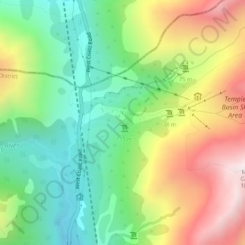
Name: Topografische Karte waterfall, Höhe, Relief.
Durchschnittliche Höhe: 1.215 m
Minimale Höhe: 797 m
Maximale Höhe: 1.836 m
Andere topografische Karten
Klicken Sie auf eine Karte, um ihre Topografie, ihre Höhe und ihr Relief anzuzeigen.
Normanby
New Zealand > Canterbury > Timaru District
Normanby, Timaru District, Canterbury, 7912, New Zealand
Durchschnittliche Höhe: 12 m
Ohinepaka Bay
New Zealand > Canterbury > Christchurch City > Banks Peninsula Community > Wainui
Ohinepaka Bay, Wainui, Banks Peninsula Community, Christchurch City, Canterbury, 7582, New Zealand
Durchschnittliche Höhe: 94 m
Woodend Beach
New Zealand > Canterbury > Waimakariri District
Woodend Beach, Waimakariri District, Canterbury, 7612, New Zealand
Durchschnittliche Höhe: 3 m
Selwyn District
Selwyn District, Canterbury, New Zealand
Durchschnittliche Höhe: 679 m
Mount Livingstone
New Zealand > Canterbury > Mackenzie District
Mount Livingstone, Mackenzie District, Canterbury, New Zealand
Durchschnittliche Höhe: 1.945 m
Shalamar Reserve
New Zealand > Canterbury > Christchurch City > Christchurch
Shalamar Reserve, Cashmere, Christchurch, Christchurch City, Canterbury, New Zealand
Durchschnittliche Höhe: 48 m
Remus
New Zealand > Canterbury > Selwyn District
Remus, Selwyn District, Canterbury, New Zealand
Durchschnittliche Höhe: 620 m
Little River
Little River, Canterbury, New Zealand, Whale Island
Durchschnittliche Höhe: 9 m
Coastal-Burwood Community
New Zealand > Canterbury > Christchurch City
Coastal-Burwood Community, Christchurch City, Canterbury, New Zealand
Durchschnittliche Höhe: 6 m
Zig Zag
New Zealand > Canterbury > Christchurch City > Banks Peninsula Community
Zig Zag, Banks Peninsula Community, Christchurch City, Canterbury, New Zealand
Durchschnittliche Höhe: 136 m
West Melton
New Zealand > Canterbury > Selwyn District
West Melton, Selwyn District, Canterbury, 7618, New Zealand
Durchschnittliche Höhe: 88 m
Boulder Col
New Zealand > Canterbury > Ashburton District
Boulder Col, Upper Lake Heron Station, Ashburton District, Canterbury, New Zealand
Durchschnittliche Höhe: 1.838 m
Christchurch City
Christchurch City, Canterbury, New Zealand
Durchschnittliche Höhe: 74 m
Philosophers Knob
New Zealand > Canterbury > Hurunui District
Philosophers Knob, Hurunui District, Canterbury, New Zealand
Durchschnittliche Höhe: 1.518 m
Hanmer Springs
New Zealand > Canterbury > Hurunui District
Hanmer Springs, Hurunui District, Canterbury, 7334, New Zealand
Durchschnittliche Höhe: 397 m
Halswell-Hornby-Riccarton Community
New Zealand > Canterbury > Christchurch City
Halswell-Hornby-Riccarton Community, Christchurch City, Canterbury, New Zealand
Durchschnittliche Höhe: 49 m
Red Hill
New Zealand > Canterbury > Selwyn District
Red Hill, Selwyn District, Canterbury, New Zealand
Durchschnittliche Höhe: 1.182 m
Kaiapoi
New Zealand > Canterbury > Waimakariri District
Kaiapoi, Waimakariri District, Canterbury, 7630, New Zealand
Durchschnittliche Höhe: 5 m
Alpine Tarn
New Zealand > Canterbury > Mackenzie District
Alpine Tarn, Mackenzie District, Canterbury, New Zealand
Durchschnittliche Höhe: 1.088 m
Lyttelton
New Zealand > Canterbury > Christchurch City > Banks Peninsula Community
Lyttelton, Banks Peninsula Community, Christchurch City, Canterbury, 8082, New Zealand
Durchschnittliche Höhe: 99 m
Linwood-Central-Heathcote Community
New Zealand > Canterbury > Christchurch City > Linwood-Central-Heathcote Community
Linwood-Central-Heathcote Community, Christchurch City, Canterbury, New Zealand
Durchschnittliche Höhe: 55 m
Saint Albans
New Zealand > Canterbury > Christchurch City > Christchurch
Saint Albans, Fendalton-Waimari-Harewood Community, Christchurch, Christchurch City, Canterbury, New Zealand
Durchschnittliche Höhe: 10 m
Motunau Beach
New Zealand > Canterbury > Hurunui District > Motunau Beach
Motunau Beach, Hurunui District, Canterbury, New Zealand
Durchschnittliche Höhe: 27 m
Pyramid
New Zealand > Canterbury > Ashburton District
Pyramid, Ashburton District, Canterbury, New Zealand
Durchschnittliche Höhe: 1.299 m
Waiau Uwha River
Waiau Uwha River, Canterbury, 7395, New Zealand
Durchschnittliche Höhe: 916 m
Knuckles
New Zealand > Canterbury > Selwyn District
Knuckles, Selwyn District, Canterbury, New Zealand
Durchschnittliche Höhe: 980 m
Mount Lyford Village
New Zealand > Canterbury > Mount Lyford Village
Mount Lyford Village, Hurunui District, Canterbury, New Zealand
Durchschnittliche Höhe: 648 m
Waimakariri District
Waimakariri District, Canterbury, New Zealand
Durchschnittliche Höhe: 476 m
Godley Head
New Zealand > Canterbury > Christchurch
Godley Head, Linwood-Central-Heathcote Community, Christchurch, Christchurch City, Canterbury, New Zealand
Durchschnittliche Höhe: 25 m
Christchurch
New Zealand > Canterbury > Christchurch City
Christchurch, Christchurch City, Canterbury, New Zealand
Durchschnittliche Höhe: 41 m
Rolleston
New Zealand > Canterbury > Rolleston
Rolleston, Selwyn District, Canterbury, 7614, New Zealand
Durchschnittliche Höhe: 54 m
Mount Cook Village
New Zealand > Canterbury > Mount Cook Village
Mount Cook Village, Mackenzie District, Canterbury, 7946, New Zealand
Durchschnittliche Höhe: 984 m
Kurow
New Zealand > Canterbury > Kurow
Kurow, Waitaki District, Canterbury, 9435, New Zealand
Durchschnittliche Höhe: 274 m
Jacob
Jacob, Kaikōura District, Canterbury, New Zealand
Durchschnittliche Höhe: 132 m
Lake Tekapo
New Zealand > Canterbury > Lake Tekapo
Lake Tekapo, Mackenzie District, Canterbury, New Zealand
Durchschnittliche Höhe: 1.025 m
Ashburton
New Zealand > Canterbury > Ashburton
Ashburton, Ashburton District, Canterbury, 7700, New Zealand
Durchschnittliche Höhe: 99 m
Mount Wilson
Mount Wilson, Selwyn District, Canterbury, New Zealand
Durchschnittliche Höhe: 1.569 m
The Big Hill
The Big Hill, Mackenzie District, Canterbury, New Zealand
Durchschnittliche Höhe: 698 m
Timaru District
Timaru District, Canterbury, New Zealand
Durchschnittliche Höhe: 560 m
Rakaia River
Rakaia River, Ashburton District, Canterbury, 7710, New Zealand
Durchschnittliche Höhe: 217 m
Ball Glacier
Ball Glacier, Caroline hut to ball hut, Mackenzie District, Canterbury, New Zealand
Durchschnittliche Höhe: 1.324 m
Mount Catherine
Mount Catherine, Ashburton District, Canterbury, New Zealand
Durchschnittliche Höhe: 1.734 m
Southern Alps
Southern Alps, Mackenzie District, Canterbury, New Zealand
Durchschnittliche Höhe: 2.832 m
Mackenzie District
Mackenzie District, Canterbury, New Zealand
Durchschnittliche Höhe: 961 m
North Peak
North Peak, Ashburton District, Canterbury, New Zealand
Durchschnittliche Höhe: 2.112 m
The Abbot
The Abbot, Mackenzie District, Canterbury, New Zealand
Durchschnittliche Höhe: 2.088 m
Barrys Bay
New Zealand > Canterbury > Barrys Bay
Barrys Bay, Christchurch City, Canterbury, 7582, New Zealand
Durchschnittliche Höhe: 100 m
Anna Glacier
Anna Glacier, Mackenzie District, Canterbury, New Zealand
Durchschnittliche Höhe: 2.446 m