
Topografische Karte Estérel
Interaktive Karte
Klicken Sie auf die Karte, um die Höhe anzuzeigen.
Über diese Karte
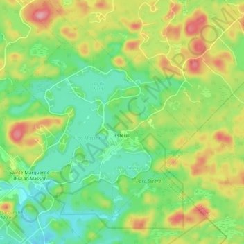
Name: Topografische Karte Estérel, Höhe, Relief.
Ort: Estérel, Les Pays-d'en-Haut, Laurentides, Québec, Canada (46.01221 -74.06024 46.07980 -73.98977)
Durchschnittliche Höhe: 370 m
Minimale Höhe: 316 m
Maximale Höhe: 454 m
Andere topografische Karten
Klicken Sie auf eine Karte, um ihre Topografie, ihre Höhe und ihr Relief anzuzeigen.
Lac Sainte-Marie
Canada > Québec > Les Pays-d'en-Haut > Saint-Adolphe-d'Howard
Lac Sainte-Marie, Saint-Adolphe-d'Howard, Les Pays-d'en-Haut, Laurentides, Québec, Canada
Durchschnittliche Höhe: 401 m
Saint-Adolphe-d'Howard
Canada > Québec > Les Pays-d'en-Haut
Saint-Adolphe-d'Howard, Les Pays-d'en-Haut, Laurentides, Québec, J0T 2B0, Canada
Durchschnittliche Höhe: 424 m
Sainte-Anne-des-Lacs
Canada > Québec > Les Pays-d'en-Haut
Sainte-Anne-des-Lacs, Les Pays-d'en-Haut, Laurentides, Québec, J0R 1B0, Canada
Durchschnittliche Höhe: 287 m
Piedmont
Canada > Québec > Les Pays-d'en-Haut
Piedmont, Les Pays-d'en-Haut, Laurentides, Québec, J0R 1K0, Canada
Durchschnittliche Höhe: 254 m
Lac Diez-d'Aux
Canada > Québec > Les Pays-d'en-Haut > Wentworth-Nord
Lac Diez-d'Aux, Wentworth-Nord, Les Pays-d'en-Haut, Laurentides, Québec, Canada
Durchschnittliche Höhe: 423 m
Saint-Sauveur
Canada > Québec > Les Pays-d'en-Haut
Saint-Sauveur, Les Pays-d'en-Haut, Laurentides, Québec, Canada
Durchschnittliche Höhe: 294 m
Sainte-Adèle
Canada > Québec > Les Pays-d'en-Haut
Sainte-Adèle, Les Pays-d'en-Haut, Laurentides, Québec, Canada
Durchschnittliche Höhe: 336 m
Ile Cook
Canada > Québec > Les Pays-d'en-Haut > Lac-des-Seize-Iles
Ile Cook, Lac-des-Seize-Iles, Les Pays-d'en-Haut, Laurentides, Québec, Canada
Durchschnittliche Höhe: 312 m