
Topografische Karte Sainte-Euphémie-sur-Rivière-du-Sud
Interaktive Karte
Klicken Sie auf die Karte, um die Höhe anzuzeigen.
Über diese Karte
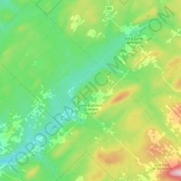
Name: Topografische Karte Sainte-Euphémie-sur-Rivière-du-Sud, Höhe, Relief.
Durchschnittliche Höhe: 386 m
Minimale Höhe: 267 m
Maximale Höhe: 654 m
La municipalité est située dans la vaste pénéplaine du centre de la municipalité régionale de comté de Montmagny, la municipalité ayant une altitude moyenne de 335 mètres avec des collines avoisinant les 400 mètres. Le terrain est très argileux et la couche arable est constitué de schiste très peu perméable et comporte plusieurs blocs erratiques.
Andere topografische Karten
Klicken Sie auf eine Karte, um ihre Topografie, ihre Höhe und ihr Relief anzuzeigen.
Petite rivière Sainte-Marguerite
Canada > Québec > Montmagny (MRC) > Saint-François-de-la-Rivière-du-Sud
Petite rivière Sainte-Marguerite, Saint-François-de-la-Rivière-du-Sud, Montmagny (MRC), Chaudière-Appalaches, Québec, Canada
Durchschnittliche Höhe: 188 m
Saint-Fabien-de-Panet
Canada > Québec > Montmagny (MRC)
Saint-Fabien-de-Panet, Montmagny (MRC), Chaudière-Appalaches, Québec, Canada
Durchschnittliche Höhe: 438 m
Lac-Frontière
Canada > Québec > Montmagny (MRC)
Lac-Frontière, Montmagny (MRC), Chaudière-Appalaches, Québec, Canada
Durchschnittliche Höhe: 384 m
Saint-Pierre-de-la-Rivière-du-Sud
Canada > Québec > Montmagny (MRC)
Saint-Pierre-de-la-Rivière-du-Sud, Montmagny (MRC), Chaudière-Appalaches, Québec, Canada
Durchschnittliche Höhe: 134 m
Saint-Antoine-de-l'Isle-aux-Grues
Canada > Québec > Montmagny (MRC)
Saint-Antoine-de-l'Isle-aux-Grues, Montmagny (MRC), Chaudière-Appalaches, Québec, Canada
Durchschnittliche Höhe: 21 m
Île aux Grues
Canada > Québec > Montmagny (MRC) > Saint-Antoine-de-l'Isle-aux-Grues
Île aux Grues, Saint-Antoine-de-l'Isle-aux-Grues, Montmagny (MRC), Chaudière-Appalaches, Québec, Canada
Durchschnittliche Höhe: 2 m
Morigeau
Canada > Québec > Montmagny (MRC) > Saint-François-de-la-Rivière-du-Sud
Morigeau, Saint-François-de-la-Rivière-du-Sud, Montmagny (MRC), Chaudière-Appalaches, Québec, G0R 3A0, Canada
Durchschnittliche Höhe: 58 m
Sainte-Apolline-de-Patton
Canada > Québec > Montmagny (MRC)
Sainte-Apolline-de-Patton, Montmagny (MRC), Chaudière-Appalaches, Québec, Canada
Durchschnittliche Höhe: 434 m
Saint-François-de-la-Rivière-du-Sud
Canada > Québec > Montmagny (MRC)
Saint-François-de-la-Rivière-du-Sud, Montmagny (MRC), Chaudière-Appalaches, Québec, G0R 3A0, Canada
Durchschnittliche Höhe: 99 m
Martineau
Canada > Québec > Montmagny (MRC) > Saint-François-de-la-Rivière-du-Sud
Martineau, Saint-François-de-la-Rivière-du-Sud, Montmagny (MRC), Chaudière-Appalaches, Québec, Canada
Durchschnittliche Höhe: 160 m
Saint-Paul-de-Montminy
Canada > Québec > Montmagny (MRC)
Saint-Paul-de-Montminy, Montmagny (MRC), Chaudière-Appalaches, Québec, Canada
Durchschnittliche Höhe: 484 m
Lac à Moïse
Canada > Québec > Montmagny (MRC) > Saint-Paul-de-Montminy
Lac à Moïse, Saint-Paul-de-Montminy, Montmagny (MRC), Chaudière-Appalaches, Québec, Canada
Durchschnittliche Höhe: 635 m
Lac Long
Canada > Québec > Montmagny (MRC) > Saint-Paul-de-Montminy
Lac Long, Saint-Paul-de-Montminy, Montmagny (MRC), Chaudière-Appalaches, Québec, Canada
Durchschnittliche Höhe: 525 m
Berthier-sur-Mer
Canada > Québec > Montmagny (MRC)
Berthier-sur-Mer, Montmagny (MRC), Chaudière-Appalaches, Québec, G0R 1E0, Canada
Durchschnittliche Höhe: 20 m
Lac Dominique
Canada > Québec > Montmagny (MRC) > Saint-Paul-de-Montminy
Lac Dominique, Saint-Paul-de-Montminy, Montmagny (MRC), Chaudière-Appalaches, Québec, Canada
Durchschnittliche Höhe: 508 m
Montmagny
Canada > Québec > Montmagny (MRC)
Montmagny, Montmagny (MRC), Chaudière-Appalaches, Québec, Canada
Durchschnittliche Höhe: 129 m
Notre-Dame-du-Rosaire
Canada > Québec > Montmagny (MRC)
Notre-Dame-du-Rosaire, Montmagny (MRC), Chaudière-Appalaches, Québec, G0R 2H0, Canada
Durchschnittliche Höhe: 390 m
Sainte-Lucie-de-Beauregard
Canada > Québec > Montmagny (MRC)
Sainte-Lucie-de-Beauregard, Montmagny (MRC), Chaudière-Appalaches, Québec, Canada
Durchschnittliche Höhe: 405 m
Cap-Saint-Ignace
Canada > Québec > Montmagny (MRC)
Cap-Saint-Ignace, Montmagny (MRC), Chaudière-Appalaches, Québec, G0R 1H0, Canada
Durchschnittliche Höhe: 166 m
Îles Brothers
Canada > Québec > Montmagny (MRC) > Saint-Antoine-de-l'Isle-aux-Grues
Îles Brothers, Saint-Antoine-de-l'Isle-aux-Grues, Montmagny (MRC), Chaudière-Appalaches, Québec, Canada
Durchschnittliche Höhe: 261 m
Saint-Just-de-Bretenières
Canada > Québec > Montmagny (MRC)
Saint-Just-de-Bretenières, Montmagny (MRC), Chaudière-Appalaches, Québec, G0R 3H0, Canada
Durchschnittliche Höhe: 382 m