
Topografische Karte Lions Head
Interaktive Karte
Klicken Sie auf die Karte, um die Höhe anzuzeigen.
Über diese Karte
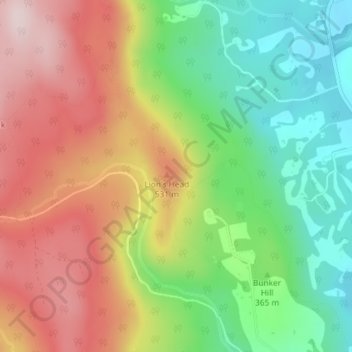
Name: Topografische Karte Lions Head, Höhe, Relief.
Ort: Lions Head, Litchfield County, Connecticut, 06968, USA (42.00726 -73.44600 42.00736 -73.44590)
Durchschnittliche Höhe: 403 m
Minimale Höhe: 226 m
Maximale Höhe: 603 m
Andere topografische Karten
Klicken Sie auf eine Karte, um ihre Topografie, ihre Höhe und ihr Relief anzuzeigen.
South Windsor
USA > Connecticut > South Windsor
South Windsor, Hartford County, Connecticut, 06074, USA
Durchschnittliche Höhe: 40 m
Wallingford
USA > Connecticut > Wallingford
Wallingford, New Haven County, Connecticut, 06492, USA
Durchschnittliche Höhe: 61 m
Poquonock
USA > Connecticut > Windsor > Poquonock
Poquonock, Windsor, Hartford County, Connecticut, 06095, USA
Durchschnittliche Höhe: 36 m
Stonington
USA > Connecticut > Stonington
Stonington, New London County, Connecticut, USA
Durchschnittliche Höhe: 3 m
Cos Cob
USA > Connecticut > Cos Cob
Cos Cob, Fairfield, Connecticut, 06807, USA
Durchschnittliche Höhe: 17 m
Major Island
Major Island, New London County, Connecticut, USA
Durchschnittliche Höhe: 16 m