
Topografische Karte Franklin
Interaktive Karte
Klicken Sie auf die Karte, um die Höhe anzuzeigen.
Franklin
According to the United States Census Bureau, the city has a total area of 29.2 square miles (75.5 km2), of which 27.5 square miles (71.1 km2) are land and 1.7 square miles (4.5 km2) are water, comprising 5.95% of the town. It is drained by the Winnipesaukee, Pemigewasset and Merrimack rivers. Webster Lake is in the north. The highest point in Franklin is an unnamed summit near the northwestern corner of the city limits, where the elevation reaches approximately 1,370 feet (420 m) above sea level. Franklin lies fully within the Merrimack River watershed.
Über diese Karte
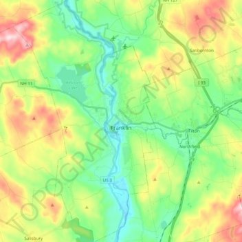
Name: Topografische Karte Franklin, Höhe, Relief.
Durchschnittliche Höhe: 201 m
Minimale Höhe: 76 m
Maximale Höhe: 431 m
Andere topografische Karten
Klicken Sie auf eine Karte, um ihre Topografie, ihre Höhe und ihr Relief anzuzeigen.
Rattlesnake Hill
United States > New Hampshire > Merrimack County > Concord
Durchschnittliche Höhe: 148 m
Webster Mills
United States > New Hampshire > Merrimack County > Pittsfield
Durchschnittliche Höhe: 168 m
Mount Kearsarge
United States > New Hampshire > Merrimack County > Wilmot
Durchschnittliche Höhe: 607 m
Shaker Village
United States > New Hampshire > Merrimack County > Canterbury
Durchschnittliche Höhe: 205 m
Rings Corner
United States > New Hampshire > Merrimack County > Pittsfield > Rings Corner
Durchschnittliche Höhe: 190 m