
Topografische Karte Srivilliputtur
Interaktive Karte
Klicken Sie auf die Karte, um die Höhe anzuzeigen.
Über diese Karte
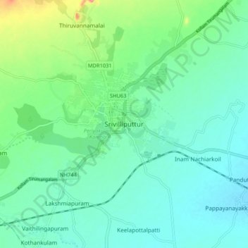
Name: Topografische Karte Srivilliputtur, Höhe, Relief.
Durchschnittliche Höhe: 149 m
Minimale Höhe: 128 m
Maximale Höhe: 217 m
Srivilliputtur is located at 9°30′58″N 77°37′48″E / 9.5161°N 77.63°E / 9.5161; 77.63. The town is located at the foothills of the Western Ghats 77 km (48 mi) south west of Madurai. It has an average elevation of 137.2 metres (450 ft) above mean sea level. There are no notable mineral resources available in and around the town. Srivilliputtur receives scanty rainfall with an average of 811 mm (31.9 in) annually, which is lesser than the state average of 1,008 mm (39.7 in). The South west monsoon, with an onset in June and lasting up to August, brings scanty rainfall. Bulk of the rainfall is received during the North East monsoon in the months of October, November and December.