
Spenden
Rüsten Sie sich für Ihr nächstes Abenteuer:
Als Amazon-Partner erhält diese Website eine Provision für qualifizierte Käufe, ohne zusätzliche Kosten für Sie.
Topografische Karte Geissholz
Klicken Sie auf die Karte, um die Höhe anzuzeigen.
Spenden
Rüsten Sie sich für Ihr nächstes Abenteuer:
Als Amazon-Partner erhält diese Website eine Provision für qualifizierte Käufe, ohne zusätzliche Kosten für Sie.
Über diese Karte
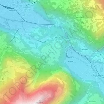
Name: Topografische Karte Geissholz, Höhe, Relief.
Durchschnittliche Höhe: 994 m
Minimale Höhe: 590 m
Maximale Höhe: 2.063 m
Spenden
Rüsten Sie sich für Ihr nächstes Abenteuer:
Als Amazon-Partner erhält diese Website eine Provision für qualifizierte Käufe, ohne zusätzliche Kosten für Sie.
Andere topografische Karten
Klicken Sie auf eine Karte, um ihre Topografie, ihre Höhe und ihr Relief anzuzeigen.
Grindelwald
Switzerland > Bern > Interlaken-Oberhasli administrative district
Durchschnittliche Höhe: 2.218 m
Interlaken
Switzerland > Bern > Interlaken-Oberhasli administrative district
Durchschnittliche Höhe: 702 m
Lauterbrunnen
Switzerland > Bern > Interlaken-Oberhasli administrative district
Durchschnittliche Höhe: 2.316 m
Lauterbrunnen
Switzerland > Bern > Interlaken-Oberhasli administrative district
Durchschnittliche Höhe: 2.316 m
Spenden
Rüsten Sie sich für Ihr nächstes Abenteuer:
Als Amazon-Partner erhält diese Website eine Provision für qualifizierte Käufe, ohne zusätzliche Kosten für Sie.
Interlaken
Switzerland > Bern > Interlaken-Oberhasli administrative district
Durchschnittliche Höhe: 701 m
Grindelwald
Switzerland > Bern > Interlaken-Oberhasli administrative district
Durchschnittliche Höhe: 2.218 m
Grindelwald
Switzerland > Bern > Interlaken-Oberhasli administrative district
Durchschnittliche Höhe: 2.218 m
Iseltwald
Switzerland > Bern > Interlaken-Oberhasli administrative district
The municipality's area also includes a large area of mountainside along the south shore of the lake, of which the lower areas are heavily wooded. These slopes extend up to the summit of the Faulhorn mountain, at an altitude of 2,680 m (8,790 ft).
Durchschnittliche Höhe: 1.218 m
Spenden
Rüsten Sie sich für Ihr nächstes Abenteuer:
Als Amazon-Partner erhält diese Website eine Provision für qualifizierte Käufe, ohne zusätzliche Kosten für Sie.
Beatenberg
Switzerland > Bern > Interlaken-Oberhasli administrative district
Durchschnittliche Höhe: 1.281 m
Meiringen
Switzerland > Bern > Interlaken-Oberhasli administrative district
On the right bank of the Aare, the municipality of Meiringen rises from an elevation of 600 m (2,000 ft) on the valley floor to the Brünig Pass at 1,008 m (3,307 ft) and beyond that to a point at 1,375 m (4,511 ft) on the slopes of the Wilerhorn. On the left bank it stretches up into the Alps and reaches an…
Durchschnittliche Höhe: 1.430 m
Bönigen
Switzerland > Bern > Interlaken-Oberhasli administrative district
Durchschnittliche Höhe: 940 m
Innertkirchen
Switzerland > Bern > Interlaken-Oberhasli administrative district > Innertkirchen
The large alpine municipality is located at the confluence of the Urbach and Gadmer streams into the Aare river. It includes the Urbach valley, the Gadmen valley, the Gen valley, the Wetterhorn mountain and the Gauli Glacier. Innertkirchen was created out of the Bäuerten (farming communities) of Grund,…
Durchschnittliche Höhe: 1.945 m
Spenden
Rüsten Sie sich für Ihr nächstes Abenteuer:
Als Amazon-Partner erhält diese Website eine Provision für qualifizierte Käufe, ohne zusätzliche Kosten für Sie.
Bönigen
Switzerland > Bern > Interlaken-Oberhasli administrative district
Durchschnittliche Höhe: 942 m
Grindelwald
Switzerland > Bern > Interlaken-Oberhasli administrative district
Durchschnittliche Höhe: 2.218 m
Brienz (BE)
Switzerland > Bern > Interlaken-Oberhasli administrative district
Durchschnittliche Höhe: 1.426 m
Interlaken
Switzerland > Bern > Interlaken-Oberhasli administrative district
Durchschnittliche Höhe: 701 m
Spenden
Rüsten Sie sich für Ihr nächstes Abenteuer:
Als Amazon-Partner erhält diese Website eine Provision für qualifizierte Käufe, ohne zusätzliche Kosten für Sie.
Grindelwald
Switzerland > Bern > Interlaken-Oberhasli administrative district
Durchschnittliche Höhe: 2.218 m
Gündlischwand
Switzerland > Bern > Interlaken-Oberhasli administrative district
Durchschnittliche Höhe: 1.268 m
Lauterbrunnen
Switzerland > Bern > Interlaken-Oberhasli administrative district
Durchschnittliche Höhe: 2.316 m
Wilderswil
Switzerland > Bern > Interlaken-Oberhasli administrative district
The municipality extends for some 8 km (5.0 mi) from the village, along the west bank of the Lütschine river, and includes the flanks of the mountains that border that valley to the west. Its altitude ranges from some 580 m (1,900 ft), on the Bödeli plain, to 2,413 m (7,917 ft), at the summit of Sulegg. It…
Durchschnittliche Höhe: 1.198 m
Spenden
Rüsten Sie sich für Ihr nächstes Abenteuer:
Als Amazon-Partner erhält diese Website eine Provision für qualifizierte Käufe, ohne zusätzliche Kosten für Sie.
Brienz (BE)
Switzerland > Bern > Interlaken-Oberhasli administrative district
Durchschnittliche Höhe: 1.426 m
Matten bei Interlaken
Switzerland > Bern > Interlaken-Oberhasli administrative district
Durchschnittliche Höhe: 781 m
Beatenberg
Switzerland > Bern > Interlaken-Oberhasli administrative district
Durchschnittliche Höhe: 1.281 m
Grindelwald
Switzerland > Bern > Interlaken-Oberhasli administrative district
Durchschnittliche Höhe: 2.218 m
Spenden
Rüsten Sie sich für Ihr nächstes Abenteuer:
Als Amazon-Partner erhält diese Website eine Provision für qualifizierte Käufe, ohne zusätzliche Kosten für Sie.
Lütschental
Switzerland > Bern > Interlaken-Oberhasli administrative district
Durchschnittliche Höhe: 1.546 m
Brienz (BE)
Switzerland > Bern > Interlaken-Oberhasli administrative district
Durchschnittliche Höhe: 1.426 m
Triftsee
Switzerland > Bern > Interlaken-Oberhasli administrative district > Innertkirchen
Durchschnittliche Höhe: 2.025 m
Lauterbrunnen
Switzerland > Bern > Interlaken-Oberhasli administrative district
Durchschnittliche Höhe: 2.316 m
Spenden
Rüsten Sie sich für Ihr nächstes Abenteuer:
Als Amazon-Partner erhält diese Website eine Provision für qualifizierte Käufe, ohne zusätzliche Kosten für Sie.
Meiringen
Switzerland > Bern > Interlaken-Oberhasli administrative district
On the right bank of the Aare, the municipality of Meiringen rises from an elevation of 600 m (2,000 ft) on the valley floor to the Brünig Pass at 1,008 m (3,307 ft) and beyond that to a point at 1,375 m (4,511 ft) on the slopes of the Wilerhorn. On the left bank it stretches up into the Alps and reaches an…
Durchschnittliche Höhe: 1.430 m
Beatenberg
Switzerland > Bern > Interlaken-Oberhasli administrative district
Durchschnittliche Höhe: 1.281 m
Matten bei Interlaken
Switzerland > Bern > Interlaken-Oberhasli administrative district
Durchschnittliche Höhe: 781 m
Brienz (BE)
Switzerland > Bern > Interlaken-Oberhasli administrative district
Durchschnittliche Höhe: 1.426 m
Spenden
Rüsten Sie sich für Ihr nächstes Abenteuer:
Als Amazon-Partner erhält diese Website eine Provision für qualifizierte Käufe, ohne zusätzliche Kosten für Sie.
Interlaken
Switzerland > Bern > Interlaken-Oberhasli administrative district
Durchschnittliche Höhe: 701 m
Innertkirchen
Switzerland > Bern > Interlaken-Oberhasli administrative district
The large alpine municipality is located at the confluence of the Urbach and Gadmer streams into the Aare river. It includes the Urbach valley, the Gadmen valley, the Gen valley, the Wetterhorn mountain and the Gauli Glacier. Innertkirchen was created out of the Bäuerten (farming communities) of Grund,…
Durchschnittliche Höhe: 1.963 m
Lauterbrunnen
Switzerland > Bern > Interlaken-Oberhasli administrative district
Durchschnittliche Höhe: 2.316 m
Guttannen
Switzerland > Bern > Interlaken-Oberhasli administrative district
By Swiss standards, the municipality is large in area; by comparison it is larger than the entire Canton of Appenzell Innerrhoden. In elevation it stretches from the valley floor which is between 800–1,300 m (2,600–4,300 ft) into the high alpine peaks of the Finsteraarhorn group.
Durchschnittliche Höhe: 2.334 m
Spenden
Rüsten Sie sich für Ihr nächstes Abenteuer:
Als Amazon-Partner erhält diese Website eine Provision für qualifizierte Käufe, ohne zusätzliche Kosten für Sie.
Gsteigwiler
Switzerland > Bern > Interlaken-Oberhasli administrative district > Gsteigwiler
Durchschnittliche Höhe: 984 m
Unteraargletscher
Switzerland > Bern > Interlaken-Oberhasli administrative district > Guttannen
Durchschnittliche Höhe: 2.631 m