
Spenden
Rüsten Sie sich für Ihr nächstes Abenteuer:
Als Amazon-Partner erhält diese Website eine Provision für qualifizierte Käufe, ohne zusätzliche Kosten für Sie.
Topografische Karte Marble
Klicken Sie auf die Karte, um die Höhe anzuzeigen.
Spenden
Rüsten Sie sich für Ihr nächstes Abenteuer:
Als Amazon-Partner erhält diese Website eine Provision für qualifizierte Käufe, ohne zusätzliche Kosten für Sie.
Über diese Karte
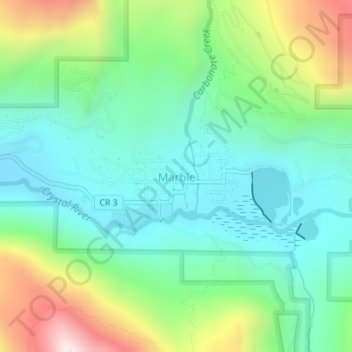
Name: Topografische Karte Marble, Höhe, Relief.
Ort: Marble, Gunnison County, Colorado, United States (39.06769 -107.19962 39.07676 -107.18179)
Durchschnittliche Höhe: 2.611 m
Minimale Höhe: 2.391 m
Maximale Höhe: 3.121 m
Spenden
Rüsten Sie sich für Ihr nächstes Abenteuer:
Als Amazon-Partner erhält diese Website eine Provision für qualifizierte Käufe, ohne zusätzliche Kosten für Sie.
Andere topografische Karten
Klicken Sie auf eine Karte, um ihre Topografie, ihre Höhe und ihr Relief anzuzeigen.
Crested Butte
United States > Colorado > Gunnison County
At the 2020 United States Census, the town had a total area of 535 acres (2.166 km2), all of it land. Crested Butte lies at an elevation of 8,885 feet (2,708 m) above sea level.
Durchschnittliche Höhe: 2.798 m
Monarch Pass
United States > Colorado > Gunnison County
Monarch Pass (elevation 11,312 feet (3,448 m)) is a high mountain pass in central Colorado, in the Rocky Mountains of the western United States.
Durchschnittliche Höhe: 3.419 m
Spenden
Rüsten Sie sich für Ihr nächstes Abenteuer:
Als Amazon-Partner erhält diese Website eine Provision für qualifizierte Käufe, ohne zusätzliche Kosten für Sie.
Crested Butte
United States > Colorado > Gunnison County
At the 2020 United States census, the town had a total area of 535 acres (2.166 km2), all of it land. Crested Butte lies at an elevation of 8,885 feet (2,708 m) above sea level.
Durchschnittliche Höhe: 2.798 m
Spenden
Rüsten Sie sich für Ihr nächstes Abenteuer:
Als Amazon-Partner erhält diese Website eine Provision für qualifizierte Käufe, ohne zusätzliche Kosten für Sie.
Crystal
United States > Colorado > Gunnison County
The elevation of Crystal is centered at 8,950 ft (2,728 m), however the area in and around crystal ranges from 8,500 ft (2,590.8 m) to peaks of 13,500 ft (4,114.8 m). The land is well drained, and the rock types, such as limestone, create very steep slopes, common in the Rocky Mountains. The area is described…
Durchschnittliche Höhe: 3.146 m
Spenden
Rüsten Sie sich für Ihr nächstes Abenteuer:
Als Amazon-Partner erhält diese Website eine Provision für qualifizierte Käufe, ohne zusätzliche Kosten für Sie.