
Topografische Karte Peter Detmold Park Dog Run
Interaktive Karte
Klicken Sie auf die Karte, um die Höhe anzuzeigen.
Über diese Karte
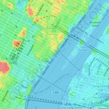
Name: Topografische Karte Peter Detmold Park Dog Run, Höhe, Relief.
Durchschnittliche Höhe: 14 m
Minimale Höhe: -9 m
Maximale Höhe: 63 m
Andere topografische Karten
Klicken Sie auf eine Karte, um ihre Topografie, ihre Höhe und ihr Relief anzuzeigen.
Staten Island
États-Unis d'Amérique > New York > New York
Staten Island, Richmond County, New York, États-Unis d'Amérique
Durchschnittliche Höhe: 11 m
Manhattan
États-Unis d'Amérique > New York > New York
Chinatown, Manhattan Community Board 3, Manhattan, New York County, New York, États-Unis d'Amérique
Durchschnittliche Höhe: 12 m
BK
États-Unis d'Amérique > New York > New York
BK, Kings County, New York, États-Unis d'Amérique
Durchschnittliche Höhe: 10 m
Kings County
États-Unis d'Amérique > New York > New York
Kings County, New York, États-Unis d'Amérique
Durchschnittliche Höhe: 9 m
New York County
États-Unis d'Amérique > New York > New York
New York County, New York, États-Unis d'Amérique
Durchschnittliche Höhe: 16 m