
Topografische Karte Effingham
Interaktive Karte
Klicken Sie auf die Karte, um die Höhe anzuzeigen.
Über diese Karte
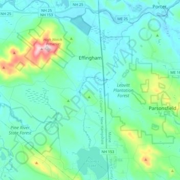
Name: Topografische Karte Effingham, Höhe, Relief.
Durchschnittliche Höhe: 188 m
Minimale Höhe: 110 m
Maximale Höhe: 571 m
According to the United States Census Bureau, the town has a total area of 39.6 square miles (103 km2), of which 38.4 square miles (99 km2) is land and 1.2 square miles (3.1 km2) is water, comprising 2.98% of the town. Green Mountain, elevation 1,884 feet (574 m) above sea level, is the highest point in town. Effingham is drained by the Ossipee River and the Ossipee's tributaries, the Pine and South rivers. Province Lake lies partially within the town's borders to the south, and small portions of Ossipee Lake (Broad Bay and Berry Bay) are contained to the north. The community is bounded on the east by the Maine state line, and on the north by the Ossipee River. Effingham lies fully within the Saco River watershed. Effingham lies partially in the Ossipee River watershed, home to the largest stratified-drift aquifer east of the Mississippi River. Much of Effingham's land serves as aquifer recharge areas.