
Topografische Karte Oyoor
Interaktive Karte
Klicken Sie auf die Karte, um die Höhe anzuzeigen.
Über diese Karte
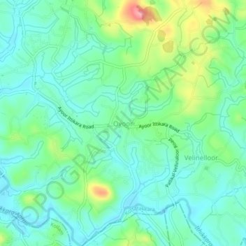
Name: Topografische Karte Oyoor, Höhe, Relief.
Ort: Oyoor, Kottarakkara, Kollam District, Kerala, 691510, India (8.85483 76.75348 8.89483 76.79348)
Durchschnittliche Höhe: 40 m
Minimale Höhe: 6 m
Maximale Höhe: 133 m
Andere topografische Karten
Klicken Sie auf eine Karte, um ihre Topografie, ihre Höhe und ihr Relief anzuzeigen.
Velinalloor
India > Kerala > Kottarakkara > Velinelloor
Velinalloor, Velinelloor, Kottarakkara, Kollam District, Kerala, 691516, India
Durchschnittliche Höhe: 55 m
Valakom
India > Kerala > Kottarakkara
Valakom, Kottarakkara, Kollam District, Kerala, 691532, India
Durchschnittliche Höhe: 79 m
Madathara
India > Kerala > Kottarakkara
Madathara, Kottarakkara, Kollam District, Kerala, 691541, India
Durchschnittliche Höhe: 180 m
Kottarakkara
India > Kerala > Kottarakkara
Kottarakkara, Kollam District, Kerala, 691500, India
Durchschnittliche Höhe: 54 m
Murukkumon
India > Kerala > Kottarakkara
Murukkumon, Kottarakkara, Kollam, Kerala, 691535, India
Durchschnittliche Höhe: 85 m
Kanakamala
India > Kerala > Kottarakkara > Chithara
Kanakamala, Chithara, Kottarakkara, Kollam, Kerala, India
Durchschnittliche Höhe: 147 m